(Created page with "Air Navigation Android") |
(Created page with "300pxVielen Dank für Ihr Interesse an Air Navigation Pro. Air Navigation wurde ursprünglich für Apple Geräte (iOS 4 oder höher) entworfe...") |
||
| Line 2: | Line 2: | ||
<br /> | <br /> | ||
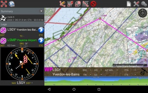
| − | [[File:ANDROID.jpg|border|right|300px]] | + | [[File:ANDROID.jpg|border|right|300px]]Vielen Dank für Ihr Interesse an Air Navigation Pro. Air Navigation wurde ursprünglich für Apple Geräte (iOS 4 oder höher) entworfen. Air Navigation wurde mit Sicht auf General Aviation entwickelt, es wurde schnell von Piloten unterschiedlicher Flugvehikel inklusive Gleitschirmen, Segelflugzeugen, Ultraleichtflugzeugen, Einzel- oder mehrmotorigen Flugzeugen, Helikoptern oder sogar Heißluftballons, angenommen. |
After receiving positive feedback from users all over the world, we decided to take Air Navigation to the Android platform. Our goal is to implement as many tools and features as we offer on Air Navigation iOS, by releasing regular updates. | After receiving positive feedback from users all over the world, we decided to take Air Navigation to the Android platform. Our goal is to implement as many tools and features as we offer on Air Navigation iOS, by releasing regular updates. | ||
Revision as of 19:33, 12 November 2015
After receiving positive feedback from users all over the world, we decided to take Air Navigation to the Android platform. Our goal is to implement as many tools and features as we offer on Air Navigation iOS, by releasing regular updates.
Contents
Introduction
Air Navigation is an affordable, yet powerful flight planning and real-time navigation application. We hope you will enjoy the product as much as we enjoyed working on it.
Installation
Here you will find some tips on getting started with Air Navigation and how to optimize your usage.
User interface
The user interface is different depending on the device that is being used.
Moving map
The moving map is the main instrument of Air Navigation. It is used for real time navigation as well as route planning or creation of user waypoints.
Tools/features
Besides the moving map and navigation instruments, various tools are available to help with flight planning and other tasks.
Xample Services
Get the full potential of all the features by connecting Air Navigation with your Xample Services account.
Simulators
External devices
Getting support
