(Updating to match new version of source page) |
|||
| Line 2: | Line 2: | ||
<br /> | <br /> | ||
---- | ---- | ||
| − | + | You can filter the obstacles by the vertical separation between them and your actual altitude. You can also check the release date of the database. | |
<br /> | <br /> | ||
__TOC__ | __TOC__ | ||
<br /> | <br /> | ||
| − | ==''' | + | =='''Obstacles options'''== |
---- | ---- | ||
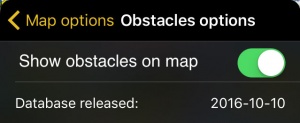
| − | === | + | === Show obstacles on map === |
| − | + | Will show or hide the obstacles on the moving map. | |
| − | === | + | === Database released: === |
| − | + | Will display the date of release of the obstacles' database. | |
[[File:obstacles_.jpg|300px]] | [[File:obstacles_.jpg|300px]] | ||
| − | ==''' | + | =='''Obstacles filter'''== |
---- | ---- | ||
| − | + | By touching the button on the bar and dragging left or right you will be able to filter the obstacles shown on the moving map according to your actual altitude and the value you set on the filter. When the filter is in full right position, all obstacles will be shown. | |
| + | |||
| + | [[File:hide_obstacles.jpg|300px]] | ||
| + | |||
| + | =='''Power lines colors'''== | ||
| + | ---- | ||
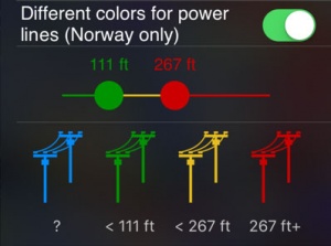
| + | This function allows you to change the color of the power lines according to their altitude. By touching and holding the colored circles, you can toggle between the different colors. | ||
| + | |||
| + | [[File:Power_lines.jpg|300px]] | ||
| + | |||
| + | ---- | ||
| + | <u>Note:</u> Please note that this feature is only available for Norway. | ||
| + | ---- | ||
| + | |||
[[File:hide_obstacles.jpg|300px]] | [[File:hide_obstacles.jpg|300px]] | ||
Revision as of 19:51, 17 March 2017
You can filter the obstacles by the vertical separation between them and your actual altitude. You can also check the release date of the database.
Contents
Obstacles options
Show obstacles on map
Will show or hide the obstacles on the moving map.
Database released:
Will display the date of release of the obstacles' database.
Obstacles filter
By touching the button on the bar and dragging left or right you will be able to filter the obstacles shown on the moving map according to your actual altitude and the value you set on the filter. When the filter is in full right position, all obstacles will be shown.
Power lines colors
This function allows you to change the color of the power lines according to their altitude. By touching and holding the colored circles, you can toggle between the different colors.
Note: Please note that this feature is only available for Norway.
Solución a problemas comunes
- Ningún obstáculo se muestra en el mapa móvil
- Asegúrese de haber adquirido correctamente la suscripción a la base de datos de obstáculos a través de Xample Services y que tenga la opción "Mostrar obstáculos" activada.
- Los obstáculos están desactualizados
- Verifique en el Map Store si hay actualizaciones disponibles para la base de datos de obstáculos.
- Adquirí la base de datos de obstáculos a través de Xample Services pero no puedo instalarla
- Asegúrese de estar conectado correctamente a su cuenta de Xample Services en Herramientas - Air Navigation Services. Instale la base de datos desde el menú Add-ons (Mapas/Productos) - Todos mis productos
Volver a la página anterior.


