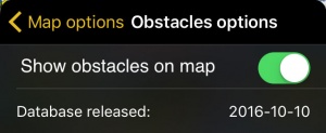
Es posible filtrar los obstáculos por la separación vertical entre ellos y su altitud actual. También se puede chequear la fecha de lanzamiento de la base de datos.
Contents
Opciones de obstáculos
Mostrar obstáculos en el mapa
Se mostrarán o se ocultarán los obstáculos en el mapa móvil.
Lanzamiento de la base de datos:
Mostrará la fecha del lanzamiento de la base de datos de obstáculos.
Filtrar obstáculos
Al tocar en el botón de la barra y arrastrar de izquierda a derecha se podrá filtrar los obstáculos mostrados en el mapa móvil de acuerdo a su altitud actual y el valor puesto en el filtro. Cuando el filtro esté posicionado en el extremo derecho, se mostrarán todos los obstáculos.
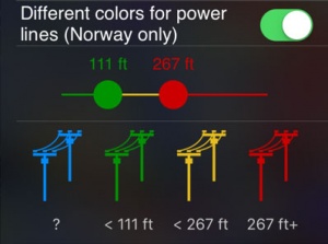
Power lines colors
This function allows you to change the color of the power lines according to their altitude. By touching and dragging right and left the colored circles, you can toggle between the different colors.
Nota: Esta función está disponible solo para Noruega.
Troubleshooting
- No obstacles are shown on the Moving Map
- Make sure that you have correctly acquired the Obstacles database subscription in Xample Services and you have turned on the option "Show obstacles on Map".
- Obstacles are out of date
- Check in the Map Store if there is an update available for the Obstacles database.
- I acquired the Obstacles Database via Xample Services but I'm not able to install it
- Check that you are correctly connected to your Xample Services account under Tools - Air Navigation Services. Install the database from the Map Store - All my products menu.
Back to previous page.


