|
|
| Line 2: |
Line 2: |
| | <br /> | | <br /> |
| | ---- | | ---- |
| − | [[File:plane arrow.jpg|caption|left]] On a mobile, this button toggles the moving map data bar visibility on/off. On a tablet, this button toggles between '''Split-screen''' and '''Full-screen''' mode. The split screen shows the HSI instrument and the Route module on the left side of the screen. | + | [[File:plane arrow.jpg|caption|left]] Numa Tablet, este botão permite passar duma '''tela dividida''a uma '''tela completa'''. Num celular, este botão permite ativar ou desativar a barra de dados do mapa móvel. |
| − | <br/> | + | <br /> |
| − | [[File:little world.jpg|caption|left]] '''«Map options»''' displays the '''Map Settings''', where you can configure what will be displayed on the map and how. You will find options to configure the Airspace format, filter waypoints, enable/disable the Elevation Graph and more. | + | [[File:little world.jpg|caption|left]] '''«Map options»''' exibe o módulo de '''ajuste de mapas''', No ajuste de mapas, você pode configurar o que vai aparecer no mapa e como. Por exemplo, você pode escolher e tirar mapas/cartas que estão sendo mostrados como fundo de tela. |
| − | <br/> | + | <br /> |
| − | [[File:lil pencil.jpg|caption|left]] Toggles between Flight mode and '''Edit mode'''. When Edit mode is turned on, a yellow-black bar at the top of the screen indicates it is active. It is possible to tap waypoints on the map to add/remove them to/from a current route and also press and drag a leg up to a waypoint to include it in the created route as well. | + | [[File:lil pencil.jpg|caption|left]] Permite trocar de modo de vôo a '''modo de edição'''. Quando o modo de edição está aceso, é possível pressionar os waypoints no mapa para adicioná-los ou tirá-los desde ou até a rota atual. Também é possível inserir um waypoint novo pressionando sobre uma perna e movendo até uma nova localização. |
| − | <br/> | + | <br /> |
| − | [[File:wp icon.jpg|caption|left]] Displays the waypoint database where it is possible to '''Search''' for a particular waypoint or list nearby waypoints, sorted by distance. The search can be done by Airport name, city name, ICAO code, or directly by accessing to the list of countries. | + | [[File:wp icon.jpg|caption|left]] Exibe uma base de dados de waypoints, quando for possível, para procurar uma listagem particular deles ou uma listagem dos que estão mais próximos, classificados pelas distancias. |
| − | <br/> | + | <br /> |
| − | [[File:rte icon.jpg|caption|left]] Displays the list of '''stored Routes.''' Tapping on a route from the list will set this route as current, displaying the legs in the '''«Route module»''' and displaying the route in the moving map. | + | [[File:rte icon.jpg|caption|left]] Exibe a listagem de '''rotas salvadas'''. Pressionando numa rota desde a listagem, você poderá selecionar esta rota como a atual, exibindo as pernas no '''«Route module»''' e exibindo a rota no mapa móvel como um vetor magenta. |
| − | <br/> | + | <br /> |
| − | [[File:circle icon.jpg|caption|left]] Selects the '''Nearest Airfield''' from your current location as a direct-to waypoint. | + | [[File:circle icon.jpg|caption|left]] Seleciona o '''aeródromo mais próximo''' da sua posição atual. |
| − | <br/> | + | <br /> |
| | | | |
| | | | |
Revision as of 20:10, 19 November 2015
Numa Tablet, este botão permite passar duma
tela divididaa uma tela completa'. Num celular, este botão permite ativar ou desativar a barra de dados do mapa móvel.
«Map options» exibe o módulo de
ajuste de mapas, No ajuste de mapas, você pode configurar o que vai aparecer no mapa e como. Por exemplo, você pode escolher e tirar mapas/cartas que estão sendo mostrados como fundo de tela.
Permite trocar de modo de vôo a
modo de edição. Quando o modo de edição está aceso, é possível pressionar os waypoints no mapa para adicioná-los ou tirá-los desde ou até a rota atual. Também é possível inserir um waypoint novo pressionando sobre uma perna e movendo até uma nova localização.
Exibe uma base de dados de waypoints, quando for possível, para procurar uma listagem particular deles ou uma listagem dos que estão mais próximos, classificados pelas distancias.
Exibe a listagem de
rotas salvadas. Pressionando numa rota desde a listagem, você poderá selecionar esta rota como a atual, exibindo as pernas no
«Route module» e exibindo a rota no mapa móvel como um vetor magenta.
Seleciona o
aeródromo mais próximo da sua posição atual.
Eliminates the Route from the Map in order to fly freely without following any legs.
It also Hides the Approach Charts from the Map as well.
The
«Document Browser» allows the user to create an
Aircraft profile to use with Air Nav Pro. On a mobile, this tool is reachable from the «Config» tab at the bottom right corner .
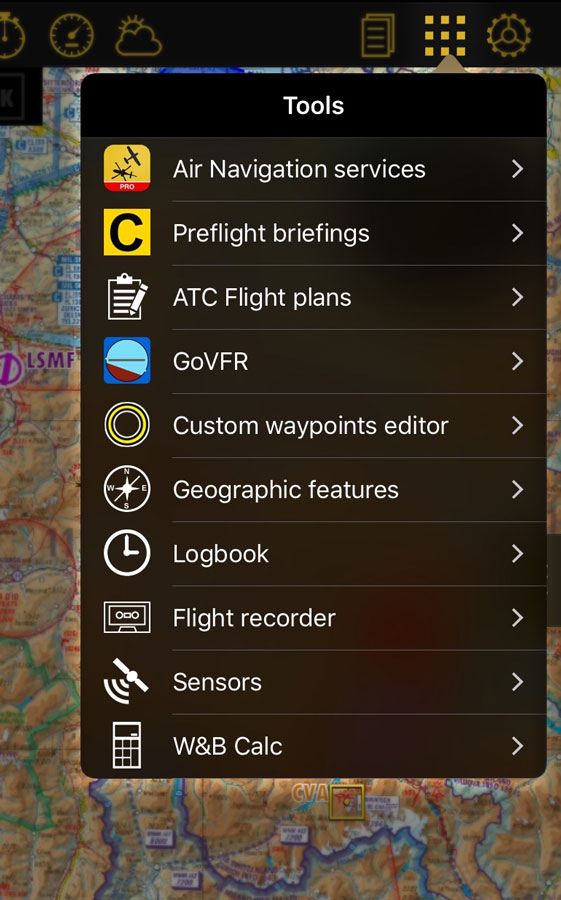
Displays the
Tools list where you can find additional utilities. On a mobile, the tools are reachable from the «Config» tab at the bottom right corner.
«Config» button displays the application behavior and customize units and other
Settings. On a mobile, the settings are reachable from the «Config» tab at the bottom-right corner.
Back to index.


