To import a list of waypoints with the embedded Webserver, the data must be formatted as a tab separated text file, encoded as UTF8 to support special characters.
You can use your favorite spreadsheet application or convert waypoints from another database to match the structure described below.
We strongly recommend that you create a custom waypoint on the iPhone/iPod first and download it from the website to get the correct file structure, then you don’t have to type the columns names manually (which could result in typos and/or bad structure that would not be recognized as a valid file on importation).
File structure for waypoints
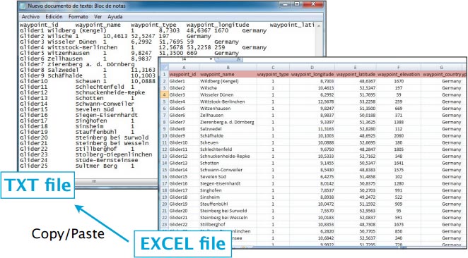
To be valid, a waypoint file must start with a row listing the columns names separated by a tab character (TAB key). The other lines are the actual waypoints values (one line per waypoint). Values can be empty but they must be separated by a tab character.
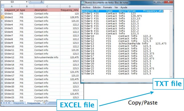
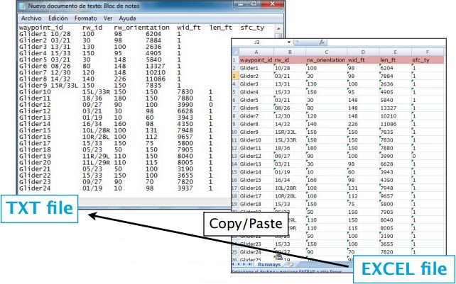
The best would be to work on MS EXCEL and when having finished, then copy the columns and paste them into a TXT file with a program like «Notepad»:
Columns names and definition are:
- waypoint_id (text, usually less than 6 characters, required value)
- waypoint_name (text, longer description of the waypoint)
- waypoint_type (number: 1=Airport, 2=fix, 3=waypoint, 4=Helipad, 5=seaplane base, 8=IFR waypoint, 10=DME, 11=NDB, 12=VOR, 13=NDB/DME, 14=VOR/DME, 15=TACAN, 16=VORTAC)
- waypoint_longitude (number with decimal)
- waypoint_latitude (number with decimal)
- waypoint_elevation (number, elevation in feet)
- waypoint_country (text)
- waypoint_state (text, example California)
- waypoint_channel (text)
- waypoint_frequency (number, for navaids only)
- main_runway_orientation (number 1 to 360)
File structure for frequencies
To be valid, a frequencies file must start with a row listing the columns names separated by a tab character. The other lines are the actual frequencies values (1 line per frequency). Values can be empty but they must be separated by a tab character.
Columns names and definition are:
- waypoint_id (text, must match a waypoint waypoint_id to be associated with it)
- type (text, short name of the frequency)
- description (text, long name of the frequency)
- frequency_mhz (number with decimal, the actual frequency).
File structure for runways
To be valid, a runways file must start with a row listing the columns names separated by a tab character. The other lines are the actual runways values (1 line per runway). Values can be empty but they must be separated by a tab character.
Columns names and definition are:
- waypoint_id (text, must match a waypoint waypoint_id to be associated with it)
- rw_id (text, name of the runway)
- rw_orientation (number 1-360)
- wid_ft (number, width in feet)
- len_ft (number, length in feet)
- sfc_ty (number, unknown=0, Asphalt=1, Concrete=2, Grass=3, Gravel=4, Dirt=5, Sand=6, Snow=7, Ice=8, Water=9)
Back to previous page.


