- Control the screen brightness;
- Show/hide the map background (the installed charts/maps);
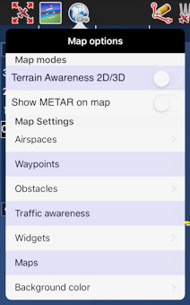
- Show/hide the terrain elevation graph;
- Enable the Terrain awareness 3D/2D;
- Show/hide symbols of weather conditions (VMC, IMC);
- Setup the airspaces filter and display modes;
- Setup the waypoints filter;
- Enable the extended track line, bearing line and runway limits extensions;
- Enable Maps/Charts and choose which map will be displayed on top of the others ;
- Choose background color (for when there is no map displayed).

