Contents
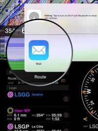
Es posible enviar y recibir datos a través de aplicaciones iOS y servicios como Airdrop o aplicaciones de terceros como Dropbox. En este artículo utilizaremos la aplicación de Mail de iOS como ejemplo de cómo importar y exportar datos.
Enviar datos
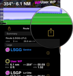
Rutas (en formato GPX). Se encontrará un botón en la parte superior derecha del módulo "Ruta".
Se puede exportar el plan de vuelo (en formato PDF) desde el módulo "Totales".
Vuelos grabados (en formato KML). Hay que dirigirse al menú «Herramientas», entrar a «Vuelos grabados» y seleccionar el vuelo deseado.
Logbook (en formato TXT). Se puede exportar dirigiéndose al menú «Herramientas» y presionando en el botón ubicado en la parte superior derecha del panel «Logbook».
Perfil de la aeronave (en formato ANP). En el menú «Document browser» hay que dirigirse al panel del perfil de la aeronave, seleccionar el perfil deseado y presionar el botón que se encuentra en la esquina superior derecha.
Waypoints (en formato ANP, GXP, Text+Google Maps links). Es posible compartir los waypoints creados a través del «Waypoints de usuario». Para mas información, dirigirse a este artículo.
Recibir datos
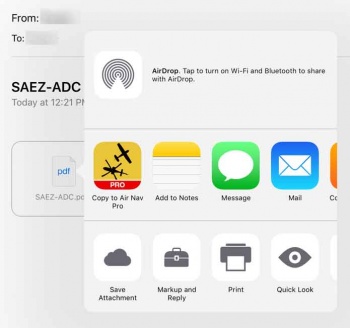
Se puede enviar un archivo compatible con Air Navigation Pro al buzón de mail y utilizar la función «Copiar a Air Nav Pro» como muestra la captura de pantalla.
This option is executed directly from the mail box on the iPad/iPhone. As you can see, there are five types of files that Air Navigation Pro can import through this method:
- PDF documents
- If you add the 4 letter ICAO code as a prefix to the file name, you can use this tool and the PDF file will be automatically installed in Air Navigation. In this case, the file will be associated to the waypoint with the same ICAO code. You can use a "-" to add more info in the name of the file.
- GPX files (routes, tracks and waypoints)
- KML (lines or area data)
- ANP Aircraft profile files
- Airspaces in OpenAir format (extension has to be .oar) and in Tim Newport-Peace format (extension has to be .air).
Volver a la página anterior.


