This page is a translated version of the page Elevation TAB and the translation is 100% complete.
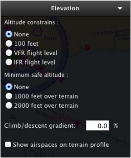
The Elevation TAB shows us the terrain profile throughout our created route. You can interact with the Elevation Graph and set the waypoints' intended overflight altitude, as well as add mid waypoints for each leg.
Elevation data must be first downloaded from the Map Store in order to display it in the graph.
You will click-on and drag a waypoint up or down in the Graph to set its desired overflight altitude.
Climb/descent gradient and airspace display will be configured from this TAB, too, and it will allow computation of top of climb and top of descent.
You can disable the altitude constrains pressing and holding the ALT key while moving a point in the graph. You can disable minimum safe altitude pressing and holding the SHIFT key.
From this TAB you will also active or hide the airspaces in the graph.
Back to index

