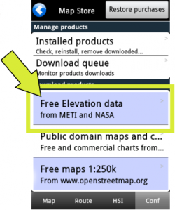
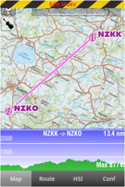
Im «Map Options» Menü können Sie die Geländeerhöhungs-Ansicht aktivieren oder deaktivieren. Diese Informationen können nur, wenn die Höhendaten für die Region installiert sind, angezeigt werden. Dafür müssen Sie die «Free Elevation data» aus dem Map Store herunterladen.
Im Flugmodus, wird das Gelände vor dem Flugzeug angezeigt, und im 5-Sekundentakt erneuert. Die Geländeansicht kann mit zwei Fingern gezoomt werden und wird in NM angezeigt. Die Maximalhöhe ist in der Geländeansicht sichtbar. Ein Symbol, welches Ihr Flugzeug darstellt, wird mit einer gestrichelten roten Linie in dieser Ansicht angezeigt, um Ihre aktuelle Höhe gemäß GPS anzuzeigen.
This is very useful when planning your route, to get an estimate of the minimum safe altitude.
Note: Please note that even with a good GPS signal, the altitude as reported by the GPS may have an accuracy of +/- 200 ft. Elevation database may also contain some inaccuracies. You should always plan your flight with a reasonable margin over the obstacles.
Back to index.

