(Created page with "VOR/CDI") |
(Created page with "---- 250pxEl instrumento VOR usa datos del GPS para desplegar la dirección hacia un waypoint. La parte superior es un emulador de indicador V...") |
||
| Line 1: | Line 1: | ||
<languages /> | <languages /> | ||
---- | ---- | ||
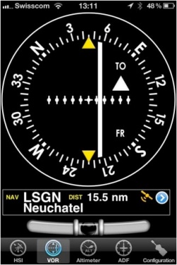
| − | [[File:qwerty.jpg|caption|left|250px]] | + | [[File:qwerty.jpg|caption|left|250px]]El instrumento VOR usa datos del GPS para desplegar la dirección hacia un waypoint. |
| − | + | La parte superior es un emulador de indicador VOR. La aguja blanca (CDI, Indicación de desviación de curso) mostrará la desviación actual hasta +/- 12 grados con respecto al radial seleccionado hasta o desde el curso del waypoint seleccionado. | |
| − | + | La selección del curso y radial se realiza al tocar y deslizar los dedos hacia arriba o abajo, a la derecha o izquierda del anillo de la brújula. | |
| − | + | Por debajo del indicador principal, el nombre de waypoint actual seleccionado es exhibido, como también la distancia desde éste y la precisión del GPS. Pueden usar cualquier tipo de waypoint (Airports, VOR, NDV, etc.) con el instrumento VOR (mientras que uno real requiere señales de radio desde transmisores VOR, VOR/DME o VORTAC). | |
| − | + | Se puede seleccionar un nuevo waypoint desde la base de datos con el botón azul localizado en la parte inferior derecha del instrumento. Por favor <u>[[Select a waypoint from the database|«Seleccionar un waypoint de la base de datos»]]</u> para obtener más información acerca de la búsqueda y selección de los mismos. | |
| − | + | ||
| − | + | ||
[[File:danger.jpg|caption|left]]A '''“NAV” warning flag''' will let you know that you should '''NOT''' trust the VOR indicator in the following cases: | [[File:danger.jpg|caption|left]]A '''“NAV” warning flag''' will let you know that you should '''NOT''' trust the VOR indicator in the following cases: | ||
Revision as of 07:45, 16 October 2015
El instrumento VOR usa datos del GPS para desplegar la dirección hacia un waypoint.
La parte superior es un emulador de indicador VOR. La aguja blanca (CDI, Indicación de desviación de curso) mostrará la desviación actual hasta +/- 12 grados con respecto al radial seleccionado hasta o desde el curso del waypoint seleccionado. La selección del curso y radial se realiza al tocar y deslizar los dedos hacia arriba o abajo, a la derecha o izquierda del anillo de la brújula. Por debajo del indicador principal, el nombre de waypoint actual seleccionado es exhibido, como también la distancia desde éste y la precisión del GPS. Pueden usar cualquier tipo de waypoint (Airports, VOR, NDV, etc.) con el instrumento VOR (mientras que uno real requiere señales de radio desde transmisores VOR, VOR/DME o VORTAC). Se puede seleccionar un nuevo waypoint desde la base de datos con el botón azul localizado en la parte inferior derecha del instrumento. Por favor «Seleccionar un waypoint de la base de datos» para obtener más información acerca de la búsqueda y selección de los mismos.
A “NAV” warning flag will let you know that you should NOT trust the VOR indicator in the following cases:- No waypoint is selected for the instrument;
- The waypoint distance is over 250 nautical miles;
- The GPS accuracy is less than 2.5 nautical miles.
Note 1: you don’t need Ground speed to get accurate information on this instrument.
Note 2: remember that you will ONLY find the spinball at the bottom of the instrument on iPhone/iPod Touch devices.
Back to index
