|
|
| Line 55: |
Line 55: |
| | ---- | | ---- |
| | | | |
| − | <!--T:11-->
| + | For further information about the file format for airspaces and waypoint, please take a look to the [[Format & Compatibility]] article. |
| − | ==[[Format & Compatibility]]==
| + | |
| | | | |
| − | Air Navigation is compatible with two well known Airspace file formats:
| |
| − | * '''OpenAir'''
| |
| − | * '''Tim Newport-Peace'''
| |
| − | <br/>
| |
| − | Both formats are easy to understand text files format describing Airspace attributes and geographic boundaries as well as lower and upper limits.
| |
| − |
| |
| − | <!--T:12-->
| |
| − | You can import airspaces files from the embedded Webserver, in the «Airspace» tab.
| |
| − |
| |
| − | <!--T:13-->
| |
| − | Important: OpenAir files must have a “.txt” file extension, Tim Newport-Peace must have an “.air” file extension.
| |
| − |
| |
| − | <!--T:14-->
| |
| − | You can find a description of the Tim New Port Peace format here:
| |
| − | http://soaringweb.org/TP/sua.html
| |
| − |
| |
| − | <!--T:15-->
| |
| − | You can find a description of the OpenAir format here:
| |
| − | http://www.winpilot.com/UsersGuide/UserAirspace.asp
| |
| − |
| |
| − | <!--T:16-->
| |
| − | Once uploaded, the airspaces should appear on the moving map.
| |
| − |
| |
| − | <!--T:17-->
| |
| − | ----
| |
| − | <u>'''Note:'''</u> OpenAir pen styles “SB” and “SP” commands are '''''NOT''''' supported.
| |
| − |
| |
| − | == Waypoints ==
| |
| − | To import a list of waypoints with the '''embedded Webserver''', the data must be formatted as a tab separated text file, encoded as UTF8 to support special characters.
| |
| − |
| |
| − | <!--T:18-->
| |
| − | You can use your favorite spreadsheet application or convert waypoints from another database to match the structure described below.
| |
| − |
| |
| − | <!--T:19-->
| |
| − | '''We strongly recommend''' that you create a custom waypoint on the iPhone/iPod first and download it from the website to get the correct file structure, then you don’t have to type the columns names manually (which could result in typos and/or bad structure that would not be recognized as a valid file on importation).
| |
| − |
| |
| − | ==== '''File structure for waypoints''' ==== <!--T:4-->
| |
| − |
| |
| − | <!--T:20-->
| |
| − | To be valid, a waypoint file must start with a row listing the columns names separated by a tab character (TAB key). The other lines are the actual waypoints values (one line per waypoint). Values can be empty but they must be separated by a tab character.
| |
| − |
| |
| − | <!--T:21-->
| |
| − | The '''best would be''' to work on MS EXCEL and when having finished, then copy the columns and paste them into a TXT file with a program like «Notepad»:
| |
| − |
| |
| − | <!--T:22-->
| |
| − | [[File:filew.jpg]]
| |
| − |
| |
| − | Columns names and definition are:
| |
| − | * waypoint_id (text, usually less than 6 characters, required value)
| |
| − | * waypoint_name (text, longer description of the waypoint)
| |
| − | * waypoint_type (number: 1=Airport, 2=fix, 3=waypoint, 4=Helipad, 5=seaplane base, 8=IFR waypoint, 10=DME, 11=NDB, 12=VOR, 13=NDB/DME, 14=VOR/DME, 15=TACAN, 16=VORTAC)
| |
| − | * waypoint_longitude (number with decimal)
| |
| − | * waypoint_latitude (number with decimal)
| |
| − | * waypoint_elevation (number, elevation in feet)
| |
| − | * waypoint_country (text)
| |
| − | * waypoint_state (text, example California)
| |
| − | * waypoint_channel (text)
| |
| − | * waypoint_frequency (number, for navaids only)
| |
| − | * main_runway_orientation (number 1 to 360)
| |
| − | <br/>
| |
| − | ==== '''File structure for frequencies''' ==== <!--T:8-->
| |
| − |
| |
| − | <!--T:23-->
| |
| − | To be valid, a frequencies file must start with a row listing the columns names separated by a tab character. The other lines are the actual frequencies values (1 line per frequency). Values can be empty but they must be separated by a tab character.
| |
| − |
| |
| − | <!--T:24-->
| |
| − | [[File:filef.jpg]]
| |
| − |
| |
| − | Columns names and definition are:
| |
| − | * '''waypoint_id''' (text, must match a waypoint waypoint_id to be associated with it)
| |
| − | * '''type''' (text, short name of the frequency)
| |
| − | * '''description''' (text, long name of the frequency)
| |
| − | * '''frequency_mhz''' (number with decimal, the actual frequency).
| |
| − | <br/>
| |
| − | ==== '''File structure for runways''' ==== <!--T:11-->
| |
| − |
| |
| − | <!--T:25-->
| |
| − | To be valid, a runways file must start with a row listing the columns names separated by a tab character. The other lines are the actual runways values (1 line per runway).
| |
| − | Values can be empty but they must be separated by a tab character.
| |
| − |
| |
| − | <!--T:26-->
| |
| − | [[File:filerr.jpg]]
| |
| − |
| |
| − | <!--T:27-->
| |
| − | Columns names and definition are:
| |
| − | * '''waypoint_id''' (text, must match a waypoint waypoint_id to be associated with it)
| |
| − | * '''rw_id''' (text, name of the runway)
| |
| − | * '''rw_orientation''' (number 1-360)
| |
| − | * '''wid_ft''' (number, width in feet)
| |
| − | * '''len_ft''' (number, length in feet)
| |
| − | * '''sfc_ty''' (number, unknown=0, Asphalt=1, Concrete=2, Grass=3, Gravel=4, Dirt=5, Sand=6, Snow=7, Ice=8, Water=9)
| |
| − | <br/>
| |
| − | ----
| |
| − | <u>'''Note:'''</u> remember that all the files described in this chapter will be '''imported''' into Air Navigation Pro through the embedded WebServer.
| |
| − |
| |
| − | <!--T:28-->
| |
| − | <br />
| |
| − |
| |
| − |
| |
| − |
| |
| − | <br/>
| |
| | ---- | | ---- |
| | Back to <u>[[Personal_data_management | previous page.]]</u> | | Back to <u>[[Personal_data_management | previous page.]]</u> |
| | <br /> | | <br /> |
| | </translate> | | </translate> |
Revision as of 20:36, 11 May 2016
How to use the Webserver
The iPhone/iPod must be connected to a wifi network. Additionally, the wifi network must be the same network as the one on your desktop computer.
The web server must be turned on in the «Settings». If the web server is on, its network address will appear just below the web server switch (see screenshot beside). Example: http://192.168.46:8080
To access the embedded web server, type this address in the URL bar in a reasonably up to date Internet Browser (Firefox 3, Safari 4, Explorer 8) on your computer and press return. Air Navigation web site should appear in your navigator.
If you fail to connect, try several times and on
different browsers.
Note: if you have the Bonjour application installed on your computer, the web server will appear automatically as part of the detected websites, in this case you don’t have to type the
IP address manually. Bonjour is installed automatically on Mac computers, on Windows it comes together with iTunes.
Should you wish to install the plugin manually, please download the latest installer at this address:
http://apple.com/support/downloads/bonjourforwindows.html
On the browser, available data is grouped by type: Navigation plans, Waypoints, Airspaces, Recorded flights, Logbook (see screenshot below).
Press on a group bar to disclose its content. Some data types can only be uploaded or deleted (Airspaces or maps), some can only be downloaded and deleted (Recorded flights) and some others can be uploaded, downloaded or deleted (Waypoints, Navigation
plans, logbook).
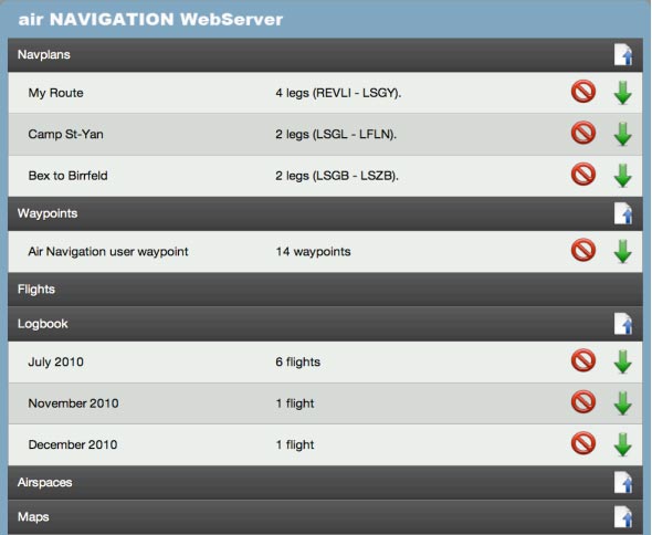
To download a file, press the green arrow on the right side of the file. The red circle is used to delete a file.
To import a file in a particular group, press the file icon with the blue arrow on the right side of the group name. A selection popup will appear on top of the page.
On most modern browser, after a file is selected, it will start uploading immediately.
On older browser, you may need to press the «Upload» button to start uploading.
To upload a PDF document and associate it to a specific airfield, you must add the ICAO code of the airport where you want the PDF to appear at the beginning of the pdf name ( Example: LSGG _Geneva_approach.pdf ). You can then upload the document in the «Appcharts» section. If Air Navigation cannot find an airfield
matching the 4 letter prefix of the file, an error message will appear and the PDF will not be installed.
For further information about the file format for airspaces and waypoint, please take a look to the Format & Compatibility article.
Back to previous page.
