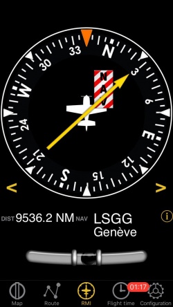
L’indicateur radiomagnétique d’Air Navigation utilise les informations du GPS et ne reçoit pas d’ondes radio.
Le radiocompas (ADF – Automatic Direction Finder) occupe la partie supérieure. L’aiguille jaune pointe vers le waypoint sélectionné qui correspond à l’axe longitudinal de l’avion.
The compass outer ring will show your current course.
Le nom du waypoint actif et sa distance sont affichés sous le cadran. Vous pouvez sélectionner n’importe type de waypoint (Aéroports, VOR, NBD, etc) comme cible de l’ADF contrairement à un vrai ADF qui nécessite des émetteur NDB ou AM comme waypoints. Vous pouvez choisir un nouveau waypoint dans la base de données grâce au bouton “i” dans la partie inférieure de l’instrument.
Please read Search Module for more information about it.
A “NAV” warning flag will let you know that you should NOT trust the ADF indicator in the following cases:- No waypoint is selected for the instrument;
- The waypoint distance is over 250 nautical miles;
- The GPS accuracy is less than 2.5 nautical miles.
Note: remember that you will ONLY find the slipball at the bottom of the instrument on iPhone/iPod Touch devices.
Back to previous page.
