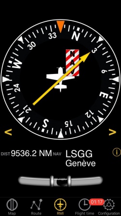
Das ADF-Instrument in Air Navigation benutzt GPS Informationen und erhält keine Radiosignale.
Der obere Teil ist der ADF-Indikator. Die gelbe Nadel zeigt in Richtung des gewählten Wegpunkts im Verhältnis zur Längsachse des Flugzeugs.
Die Kompasskarte wird Ihren aktuellen Kurs anzeigen.
Below the main indicator the name of the active waypoint is displayed as well as the distance to the waypoint. It is possible to select any kind of waypoint (Airports, VOR, NDB, etc) as an ADF target waypoint unlike with a real ADF which requires NDB or AM transmitters as waypoints. You can select a new waypoint from the database with the "i" disclosure button on the bottom part of the instrument.
Please read Search Module for more information about it.
A “NAV” warning flag will let you know that you should NOT trust the ADF indicator in the following cases:- No waypoint is selected for the instrument;
- The waypoint distance is over 250 nautical miles;
- The GPS accuracy is less than 2.5 nautical miles.
Note: remember that you will ONLY find the slipball at the bottom of the instrument on iPhone/iPod Touch devices.
Back to previous page.
