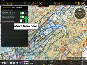
You can show/hide/overlay previously downloaded maps.
Troubleshooting
In the screenshot on the right, we show both the chart “France IGN ICAO 2015” and the chart “Switzerland 2014” one on top of the other. The problem looks like if the French chart is missing a part, but actually, it is not. This is a clear example of OVERLAYING.El problema se resuelve facilmente al mover los mapas hacia arriba o hacia abajo dede el panel «Mapas» o con tan sólo activarlos o desactivarlos. On the picture on the right, we show the chart from Uruguay on top of the one from Brazil. En la imagen sobre la derecha (arriba), el mapa de Uruguay se encuentra sobre el de Brazil. si movemos este último hacia arriba, la situación será contraria. Podemos apreciar lo explicado en la imagen de la izquierda. Cada mapa se mueve desde la marquita de tres rayas que aparece sobre la derecha del mismo.
Volver al índice
Back to index
