(Created page with "Las pestañas pueden ser desactivadas en "Configuración" - "Pestañas de información".") |
(Created page with "---- <br /> Volver al <u>índice</u>. <br />") |
||
| Line 22: | Line 22: | ||
---- | ---- | ||
| − | + | There are three kind of Docks:<br /> | |
*DEP<br /> | *DEP<br /> | ||
*ARR<br /> | *ARR<br /> | ||
*ALTN<br /> | *ALTN<br /> | ||
<br /> | <br /> | ||
| − | + | Tapping on one of the docks, will open up a tab with information related to the waypoint. To close this tab just tap anywhere on the map. | |
The tab will have four pages:<br /> | The tab will have four pages:<br /> | ||
| Line 84: | Line 84: | ||
---- | ---- | ||
<br /> | <br /> | ||
| − | + | Volver al <u>[[Air Navigation iOS/es|índice]]</u>. | |
<br /> | <br /> | ||
Revision as of 19:29, 17 December 2015
Las pestañas ofrecen un acceso rápido a información relevante sobre la salida, llegada y aeropuerto alterno.
Estas pestañas aparecerán en el costado derecho del mapa móvil luego de que una ruta sea creada o cargada.
Nota: Es posible configurar un aeropuerto alterno presionando en el resumen de rutas y agregando el ID del aeródromo en el campo alterno.
There are three kind of Docks:
- DEP
- ARR
- ALTN
Tapping on one of the docks, will open up a tab with information related to the waypoint. To close this tab just tap anywhere on the map.
The tab will have four pages:
Contents
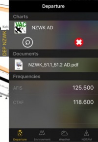
Departure/Approach
On this page you will have access to the charts and documents (*). You will also see the frequencies of the airfield. When tapping on the chart, it will be displayed on the moving map. By tapping on the red cross the chart will be closed. Tapping on the circled arrow will change to the next chart.
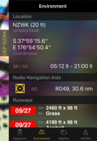
Ambiente
Se mostrará información sobre la ubicación del aeródromo y sus alrededores:- Altura
- Coordenadas
- Hora de salida/puesta del sol
- Radio ayudas de navegación: distancia y radial
- Pistas
- Obstáculos (*)
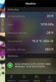
Clima
Recopila información del clima de las estaciones climáticas cercanas al aeródromo. La aplicación calculará altitudes tomando en cuenta el clima actual. También mostrará el METAR. Presionando sobre una estación, se podrá ver el reporte de TAF.
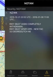
NOTAM
Nearby NOTAMS will be shown. For this page to work you will need to request a briefing first. (*)
Nota: Si hay información faltante (clima, NOTAM, etc.), cambiando del Modo Edit al Modo Flight actualizará los datos de las pestañas.
Las pestañas pueden ser desactivadas en "Configuración" - "Pestañas de información".
(*) Para que estas funciones funcionen, será necesaria la suscripción a los servicios mencionados (Preflight Briefing, Cartas de Aproximación, Base de datos de Obstáculos).
Volver al índice.


