Le HSI est le plus pratique des instruments de navigation, mais il requiert également un peu d’entraînement afin d’être utilisé efficacement.
Si la réception du GPS est mauvaise, le drapeau d’alerte indique que l’instrument n’affiche probablement pas une indication correcte.
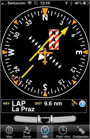
La partie en haut de l’écran contient un indicateur HSI. L’aiguille jaune est le pointeur de sélection de radiale, la partie en mouvement au milieu est l’indicateur de déviation (deviation indicator) (CDI) qui affiche la déviation (+/- 12 degrés) par rapport à la radiale sélectionnée. Contrairement à un vrai HSI où le bouton orange (Heading bug) est utilisé pour commander l’auto-pilote, Le «heading bug» affiche le cap vers le point de navigation sélectionné. Le HSI n’utilise pas le compas magnétique mais le cap de l’appareil.
!L’avantage du HSI est qu’il affiche la position de l’appareil au milieu en relation avec la radiale sélectionnée. L’indicateur de cap va effectuer une rotation afin de correspondre au cap actuel. La sélection de la radiale s’effectue par un touché-glissé déplacé avec le doigt sur la partie gauche ou droite de l’indicateur et en glissant en haut ou en bas.
File:Danger.jpgA “NAV” warning flag (as shown in the image above) will let you know that you should NOT trust the HSI indicator in the following cases:
- No waypoint is selected for the instrument;
- The waypoint distance is over 250 nautical miles;
- The GPS accuracy is bad;
- Ground speed is less than 5 Kts.
Note: Please note that you may still get correct deviation information when GPS accuracy is less than 2.5 nautical miles. In this case the compass card will be oriented to the north.
En dessous de l’indicateur principal, le point de navigation sélectionné est affiché ainsi que la distance par rapport à celui-ci (grand cercle) et le symbole de précision du GPS. Vous pouvez utiliser n’importe quel point de navigation (Airports, VOR, NDB, etc) avec l’instrument HSI. (Un vrai indicateur HSI requiert un signal radio provenant d’un émetteurs VOR, VOR/DME ou VORTAC).
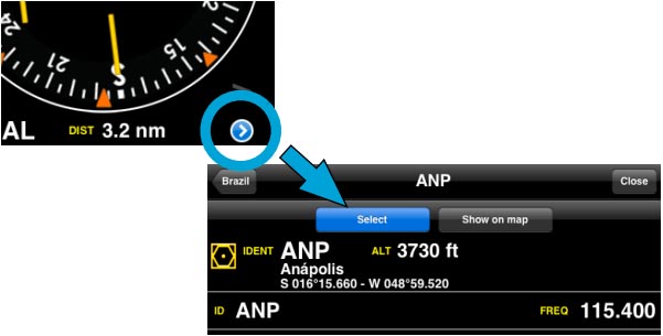
You can select a new waypoint from the database with the the blue disclosure button on the bottom part of the instrument (see screenshot). Please read «Selecting waypoints from the database» to get information about waypoint search and selection. (iOS version)
Note: remember that you will ONLY find the spinball at the bottom of the instrument on iPhone/iPod Touch devices.
Back to index (Android)
Back to index (iOS)

