![]()
En el iPhone, este botón permite visualizar/esconder la barra de datos. En el iPad, se utiliza para cambiar de «pantalla dividida» a modo de «pantalla completa». La pantalla dividida muestra dos de los instrumentos seleccionados en el mapa móvil. Este instrumento/ruta puede ser elegido desde el menú «Instrumentos a mostrar» desde el botón «Configuración» ubicado en la esquina superior derecha de la barra de herramientas.
Este botón cargará el «Módulo EFIS» (visión 3D del terreno). Antes de poder usarlo, es necesario descargar la data 3D desde el menú de «Add-ons (Mapas/Productos)». En el iPhone, se accede a este módulo desde el botón «Configuración», ubicado en esquina inferior derecha.

Las «Opciones del mapa» exhibe el módulo de ajustes del mapa. Allí, será posible configurar lo que se podrá visualizar en el mapa y cómo. Consulte el artículo siguiente «Map Options» article para más detalles. Las siguientes son las opciones que incluye este menú:
- Control the screen brightness;

- Show/hide the map background (the installed charts/maps);
- Show/hide the terrain elevation graph;
- Enable the Terrain awareness 3D/2D;
- Show/hide symbols of weather conditions (VMC, IMC);
- Setup the airspaces filter and display modes;
- Setup the waypoints filter;
- Enable the extended track line, bearing line and runway limits extensions;
- Enable Maps/Charts and choose which map will be displayed on top of the others ;
- Choose background color (for when there is no map displayed).

Pasa de «Modo de vuelo» a «Modo Editar». Cuando el modo de edición está activado, es posible presionar los waypoints en el mapa con el fin de agregarlos o removerlos de la ruta actual. También se puede insertar un nuevo waypoint al presionar sobre el vector de una pierna y arrastrarlo hacia una nueva posición. En modo de edición puede navegar en forma libre sobre el terreno 3D (módulo EFIS).
![]()
Exhibe una base de datos de waypoints en la cual es posible buscar un waypoint particular o una lista de los waypoints más cercanos (nearby), ordenados teniendo en cuenta las distancias.
![]()
Muestra la lista de rutas salvadas. Al presionar sobre una ruta de la lista, se podrá seleccionar la misma como la ruta actual, exhibiendo los waypoints en el módulo «Rutas» y mostrando las rutas en el mapa móvil como un vector color magenta.
![]()
Selecciona el aeropuerto más cercano desde su posición actual.
![]()
Se usa para borrar la ruta actual seleccionada o la dirección hacia donde el avión está yendo. Presione este botón cuando usted quisiera poner el mapa en modo “vuelo libre” o cuando desee empezar una nueva ruta en blanco. Esta herramienta es también utilizada para ocultar las cartas de aproximación.

Muestra la el registro del diario de vuelo actual (tiempos de vuelo). En el iPhone, este módulo es accedido desde la barra localizada en la parte inferior de la pantalla, y además posee un ícono ligeramente diferente.

Displays the «instruments» list. On iPhone/iPod Touch, the instruments list is reachable from the «Configuration» tab at the bottom right corner.
![]()
Displays a list of «weather stations» and latest METAR/TAF information in a decoded format. You can add stations of your choice by entering an identifier in the search field on top and press return. On iPhone/iPod touch, this module is reachable from the «Configuration» tab at the bottom right corner.

Displays a list of «PDF documents» associated to an airfield. Pressing a document will display its content in full-screen mode. You will also use this tool to create an «Aircraft profile». On iPhone/iPod Touch, this module is reachable from the «Configuration» tab at the bottom right corner.

Displays the «Tools» list where you can find additional utilities. On iPhone/iPod Touch, the tools are reachable from the «Configuration» tab at the bottom right corner. The following are the available options on this menu:
- Air Navigation Services. We refer you to «Xample Services» article in this manual;
- Preflight briefings. NOTAM service. Check «Preflight briefing» article.
- GoVFR tool. We refer you to «Third Party Services» article in this manual;

- Custom Waypoint Editor. You will be able to create user waypoints of different types (Airfield, Heliport, IFR, Navaids, etc);
- Logbook. We refer you to «Logbook» article in this manual;
- Recorded Flights. You can reproduce your flights live on this option. We refer you to «Record a Flight» article in this manual;
- Sensors. We refer you to «Sensors» article in this manual.
- W&B Calc. Weight and Balance calculator after entering the required data in the Aircraft profile.

Displays the «Settings» module where you can fine tune the application behavior and customize units and other settings. We can also find the «Map Store» module within this button, from where you can download both free and commercial maps/charts/data.

This button also displays the «Instrument Layout» menu, where the instruments are reordered on top of the list in order to appear in the «split» screen when using an iPad. In this case, only the first two will show together with the moving map. On an iPhone/iPod Touch, the «Instruments Layout» menu will reorder the first 4 instruments to show them in the Bottom bar. All the mentioned modules and settings are reachable from the «Configuration» tab at the bottom right corner on an iPhone/iPod Touch.
The following «Settings» are available:
- Units. Gives the possibility to change the units of the displayed values:
 - Distance & speed: NM&KTS, M&Mph, km&km/h;
 - Runway lengths: meters, feet;
 - Altitude: meters, feet;
 - Pressure (AHRS g mini): hPa, inHg;
 - Coordinates: DD:MM:SS, decimal, DD:MM.mm;
 - Logbook time: HH:MM, decimal.

If you wish to change Fuel/Length units, you can do this in the Aircraft profile panel.
- Map. Blocks/allows map rotation.
The option «Approach charts» allows us to choose how the geo-referenced approach charts will be open. Note that in order to use this option, you will first need to purchase the “VFR/IFR” approach charts from the Map Store (not all countries available). «TRK/Bearing» option will allow you choose from showing True North or Magnetic North when creating a Route/displaying next waypoint. When «Hidden points selectable» option is ON, the user can still select a waypoint if it's hidden.
- Instruments. You can choose from displaying the True/Magnetic North when using the Compass. When «Adjust Nav 1 to map leg» is ON, the instrument will automatically be configured to the NEXT waypoint on the map.
Remember that as it`s “Nav 1” it will only affect to the FIRST instrument of the list showing under «Instrument Layout» menu.

You can also choose to «Auto Adjust the OBS» when using the ADF, VOR and HSI. This will automatically align the arrow/CDI of the instrument in direction of the configured waypoint. Sound alerts can be activated from «Audio effects».
- Network. This will show, when enabled, the IP addresses to connect the Mac/PC with the «Embedded WebServer» or the «WebDAV server».
You also have the option for enabling «GSM download», when using 3G/4G network to download charts/data.
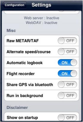
- Misc. The user can «RAW the METAR/TAF» information, enable the option that will turn the «flight recorder» ON, and have the possibility to «run the app in the background» on the iPad, if having to temporarily use another app or change settings outside Air Navigation Pro. If Air Navigation remains in the background for more than 10 minutes, it will automatically close to save energy.

«Alternate speed/course» option forces Air Nav compute the data in “time deltas” and not continuously. This will help when the GPS signal is weak and breaks of intermittently.
The «Automatic logbook» option will complete the Block-OFF/Block-ON times and the Take-OFF/Landing times automatically. Please refer to the «Logbook» article more details. «Share GPS via Bluetooth» will let PAIR the device with another one of the same nature (for example an iPad with an iPod Touch) and share the GPS signal.
- Disclaimer. Disables the “Disclaimer” message at the start of the app.
- Default. Reverts to factory settings, WITHOUT deleting or modifying existing waypoints, routes, flights or logbook.
This last option might help in case Air Navigation Pro is not working properly.
- Spinball. This option will only appear in the «Settings» section of the iPhone/iPod Touch. There is not such a feature on an iPad.
To calibrate the spinball, you have to position your iPhone/iPod Touch on a flat surface. Note that only when flying aerobatics the spinball is spinning.

Back to index