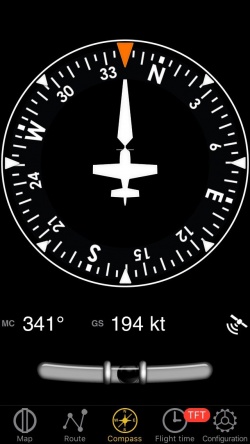
L’instrument “Boussole” affiche le cap actuel indiqué par le GPS (pas l’axe longitudinal de l’appareil) sur une boussole virtuelle animée. Le cap peut être présenté en modes “Nord vrai” ou “Nord magnétique” en fonction des réglages de l’application.
The outer ring is user adjustable by touching and sliding your finger up or down at the left or at the right of the compass indicator.
The bottom part contains the compass information, current ground speed and GPS accuracy as digital values. Units are adjustable in the settings. If the course information is magnetic, the digital course label will be “MC” (Magnetic Course) otherwise it will be “TC” (True Course).
- No waypoint is selected for the instrument;
- The waypoint distance is over 250 nautical miles;
- The GPS accuracy is less than 2.5 nautical miles.
Note: remember that you will ONLY find the slipball at the bottom of the instrument on iPhone/iPod Touch devices.
Back to previous page.
