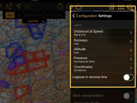
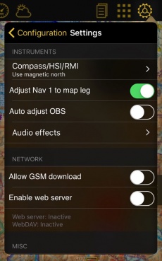
Estos son los «Ajustes» disponibles:
Contents
Unidades
Se puede cambiar las unidades de los valores mostrados:
 - Distancias & Veloc: NM&KTS, M&Mph, km&km/h;
 - Longitudes de pista: metros, pies;
 - Altitud: metros, pies;
 - Presión (AHRS g mini): hPa, inHg;
 - Coordenadas: DD:MM:SS, decimal, DD:MM.mm;
 - Logbook en decimal: HH:MM, HH.M.
Se pueden cambiar las unidades de Combustible/Brazo desde el perfil de la aeronave.
Mapa
- Rotar mapa
- Bloquea/permite la rotación del mapa.
- Cartas de aproximación
- Se puede elegir como serán mostradas las cartas de aproximación georeferenciadas.
- Manual
- Abre la carta manualmente al presionar en el ícono del aeródromo en el mapa movil.
- Auto - AD de partida/arribo
- Mostrará automáticamente la carta de aproximación del aeródromo de partida y de arribo.
- Auto - ADs en la ruta
- Mostrará las cartas de aproximación de todos los aeródromos de la ruta.
- Auto - AD más cercano
- Mostrará la carta de aproximación del aeródromo mas cercano.
- Curso/Rumbo
- Esta opción le permitirá mostrar el norte magnético o el norte verdadero al crear una ruta/mostrar el siguiente waypoint.
Instrumentos
- Brújula/HSI/RMI
- Se podría elegir si la brújula, el HSI o el RMI usarán el norte magnético o verdadero.
- Auto ajustar Nav 1
- Al activar esta función, el instrumento será configurado al próximo waypoint en el mapa. “Nav 1” significa que solo afectará al primer instrumento de la lista en el menú Instrumentos a mostrar.
- Auto ajustar OBS
- Alineará automáticamente la flecha/CDI del instrumento en la dirección del waypoint configurado en el HSI, RMI y VOR.
- Audio
- Activa los siguiente sonidos:
- Código morse de radioayudas
- Aproximación/sobrevuelo del waypoint
- Variómetro
Network
- Use mobile data for downloads
- Download charts and data over cellular network
- Enable web server
- When enabled, it will display the IP addresses to connect to the Webserver or the [Web DAV]].
Misc
- RAW METAR/TAF
- Choose if the METARs and TAFs are shown coded or decoded.
- Alternate speed/course
- Forces Air Navigation to compute the data in “time deltas” and not continuously. This will help when the GPS signal is weak and turns off intermittently.
- Automatic logbook
- Complete the Block-OFF/Block-ON times and the Take-OFF/Landing times automatically. Please refer to the «Logbook» article for more details.
- Run in background
- Allows the application to continue working although it is not active. In this case, the application will be completely closed if the device doesn't move for at least 10 minutes.
User interface
The option «Show route & position drawers» allows the user to enable tabs with relevant information about enroute position, departure, arrival and alternate airport.
Disclaimer
Disables the “Disclaimer” message at the app's launch.
Language
You can toggle from one language to another. The application is available in the following ones: English, French, German, Spanish, Italian, Portuguese, Russian and Chinese simplified. The app will need to be restarted for this change to be effect.
Diagnostic
If you are having troubles with the app, you can send a diagnostic report so our developers can analyze the issue.
Default
Reverts to factory settings, WITHOUT deleting or modifying existing waypoints, routes, flights or logbook. This last option might help in case Air Navigation Pro is not working properly.
Slipball
This option will only appear in the «Settings» section of the iPhone/iPod Touch. There is no such feature on iPads. To calibrate the spinball, you have to position your iPhone/iPod Touch on a flat surface. Note that only when flying aerobatics the spinball is spinning.
Back to previous page. (iOS)


