Contents
Crear
Existen varias maneras de crear waypoints personalizados.
- Desde el editor de waypoints del usuario.
- Desde el Módulo de búsqueda.
- A partir del Mapa Móvil
- A través de una URL.
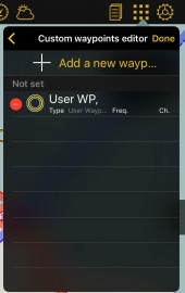
Crear waypoints desde el editor "Waypoints de usuario"
- Agregando las coordenadas exactas o usando su posición actual

Crear un waypoint desde el Mapa Móvil
- Presionando durante tres segundos sobre un punto específico en el mapa. Presionar sobre "Agregar a la base de datos" y desde allí ingresar los datos requeridos por la aplicación. Si se ha seleccionado Aeródromo como "Tipo" sera capaz de agregar la información sobre las pistas y frecuencias del mismo.
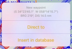

- El waypoint creado aparecerá en el mapa y desde el menu "Herramientas - Waypoints de usuario".
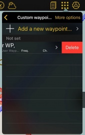
Eliminar
- Deslizando un dedo de derecha a izquierda sobre el nombre del waypoint provocar que el botón "Eliminar" aparezca.

- Desde el menu "Waypoints de usuario" presionar sobre la opción "Editar" ubicada en esquina superior derecha y elegir "Eliminar waypoints".

Back up de waypoints
Desde le modo "Editar" también podrá copiar

In order to do this, you have to connect your device to a computer and go to iTunes.
Select the device on the upper bar and then select "Apps" from the menu on the left.
At the bottom of this page you will find the "File Sharing" menu. Select Air Navigation Pro from there and save the "Backup.sql" file.

Move this file to the new device in the same way through the "File Sharing" option of iTunes. Then, select the option "Restore Waypoints" in the new device.

Easily share your waypoints with others using the "Share" function. Tap on "More Options" - "Share", choose the waypoint(s) you would like to share and tap on "Share".
You will be given the option to choose between different formats.
- Air Navigation Pro format: This format includes all the information related to the waypoint, like frequency and runways informations. Only compatible with Air Navigation Pro.
- GPX: compatible with third party softwares that supports this type of files.
- Text + Google Maps link
Once you select the waypoint you can choose how you would like to share it:
- AirDrop
- iOS Native apps like Message, Mail or Notes
- Third party apps like Dropbox.

Back to previous page.