Um eine Liste von Wegpunkten über den Webserver zu importieren, müssen die Wegpunkte als Textdatei in UTF-8 Format gespeichert sein.
Sie können Ihr bevorzugtes Tabellenkalkulationsprogramm (Excel, Numbers, usw.) benutzen oder die Daten in eine schon vorhandene Datei einfügen.
Wir empfehlen dringend, dass Sie einen Wegpunkt in der App erstellen und dass Sie die Datei dann aus dem Webserver herunterladen. Sie brauchen dann nicht die Spaltennamen manuell eintragen (und vermeiden Tipp- und Dateistrukturfehlern).
File structure for waypoints
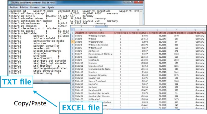
To be valid, a waypoint file must start with a row listing the columns names separated by a tab character (TAB key). The other lines are the actual waypoints values (one line per waypoint). Values can be empty but they must be separated by a tab character.
The best would be to work on MS EXCEL and when having finished, then copy the columns and paste them into a TXT file with a program like «Notepad»:
Columns names and definition are:
- waypoint_id (text, usually less than 6 characters, required value)
- waypoint_name (text, longer description of the waypoint)
- waypoint_type (number: 1=Airport, 2=fix, 3=waypoint, 4=Helipad, 5=seaplane base, 8=IFR waypoint, 10=DME, 11=NDB, 12=VOR, 13=NDB/DME, 14=VOR/DME, 15=TACAN, 16=VORTAC)
- waypoint_longitude (number with decimal)
- waypoint_latitude (number with decimal)
- waypoint_elevation (number, elevation in feet)
- waypoint_country (text)
- waypoint_state (text, example California)
- waypoint_channel (text)
- waypoint_frequency (number, for navaids only)
- main_runway_orientation (number 1 to 360)
File structure for frequencies
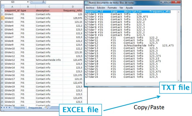
To be valid, a frequencies file must start with a row listing the columns names separated by a tab character. The other lines are the actual frequencies values (1 line per frequency). Values can be empty but they must be separated by a tab character.
Columns names and definition are:
- waypoint_id (text, must match a waypoint waypoint_id to be associated with it)
- type (text, short name of the frequency)
- description (text, long name of the frequency)
- frequency_mhz (number with decimal, the actual frequency).
File structure for runways
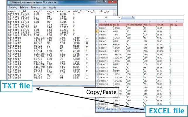
To be valid, a runways file must start with a row listing the columns names separated by a tab character. The other lines are the actual runways values (1 line per runway). Values can be empty but they must be separated by a tab character.
Columns names and definition are:
- waypoint_id (text, must match a waypoint waypoint_id to be associated with it)
- rw_id (text, name of the runway)
- rw_orientation (number 1-360)
- wid_ft (number, width in feet)
- len_ft (number, length in feet)
- sfc_ty (number, unknown=0, Asphalt=1, Concrete=2, Grass=3, Gravel=4, Dirt=5, Sand=6, Snow=7, Ice=8, Water=9)
Back to previous page.


