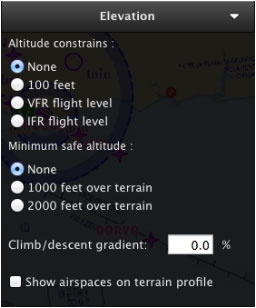
A aba “Elevation” mostra o perfil do terreno através da nossa rota criada. Você pode interagir com o gráfico do terreno e definir a altitude de sobrevôo do waypoints, assim como também adicionar waypoints intermédios para cada perna.
Os dados de elevação devem ser baixados primeiro a partir do “Map Store” a fim de ser exibidos no gráfico.
You will click-on and drag a waypoint up or down in the Graph to set its desired overflight altitude.
Climb/descent gradient and airspace display will be configured from this TAB, too, and it will allow computation of top of climb and top of descent.
You can disable the altitude constrains pressing and holding the ALT key while moving a point in the graph. You can disable minimum safe altitude pressing and holding the SHIFT key.
From this TAB you will also active or hide the airspaces in the graph.
Back to index

