(Marked this version for translation) |
|||
| Line 1: | Line 1: | ||
<translate> | <translate> | ||
| + | <!--T:1--> | ||
---- | ---- | ||
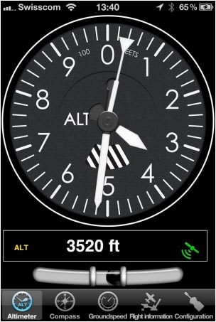
[[File:altimeter.jpg|caption|left]]The Altimeter of Air Navigation is GPS based like all nav instruments. Usually, the GPS has an acceptable precision. Nevertheless it should never be used as a replacement for the barometric altimeter. | [[File:altimeter.jpg|caption|left]]The Altimeter of Air Navigation is GPS based like all nav instruments. Usually, the GPS has an acceptable precision. Nevertheless it should never be used as a replacement for the barometric altimeter. | ||
| + | <!--T:2--> | ||
The altimeter instrument of Air Navigation displays altitudes <span style="color:#0000ff">'''above Mean sea level'''</span> ('''MSL''') as reported from the GPS unit. Usually the altitude has an '''accuracy of 70 ft or less.''' The accuracy is usually even better with external GPS modules. | The altimeter instrument of Air Navigation displays altitudes <span style="color:#0000ff">'''above Mean sea level'''</span> ('''MSL''') as reported from the GPS unit. Usually the altitude has an '''accuracy of 70 ft or less.''' The accuracy is usually even better with external GPS modules. | ||
| + | <!--T:3--> | ||
The top part is the anal og altimeter indicator. On the bottom part you will find the digital altimeter value as well as the current GPS status symbol. | The top part is the anal og altimeter indicator. On the bottom part you will find the digital altimeter value as well as the current GPS status symbol. | ||
| + | <!--T:4--> | ||
The altimeter unit can be set as feet or meters in the application settings. | The altimeter unit can be set as feet or meters in the application settings. | ||
| + | <!--T:5--> | ||
[[File:danger.jpg|caption|left]]A '''Question mark''' will show instead of a digital altimeter value when: | [[File:danger.jpg|caption|left]]A '''Question mark''' will show instead of a digital altimeter value when: | ||
* GPS accuracy is <span style="color:#0000ff">'''more than 230 ft</span>; | * GPS accuracy is <span style="color:#0000ff">'''more than 230 ft</span>; | ||
| + | <!--T:6--> | ||
<span style="color:#0000ff">'''Note:'''</span> remember that you will ONLY find the spinball at the bottom of the instrument on iPhone/iPod Touch devices. | <span style="color:#0000ff">'''Note:'''</span> remember that you will ONLY find the spinball at the bottom of the instrument on iPhone/iPod Touch devices. | ||
---- | ---- | ||
Revision as of 13:46, 25 September 2015
The Altimeter of Air Navigation is GPS based like all nav instruments. Usually, the GPS has an acceptable precision. Nevertheless it should never be used as a replacement for the barometric altimeter.
The altimeter instrument of Air Navigation displays altitudes above Mean sea level (MSL) as reported from the GPS unit. Usually the altitude has an accuracy of 70 ft or less. The accuracy is usually even better with external GPS modules.
The top part is the anal og altimeter indicator. On the bottom part you will find the digital altimeter value as well as the current GPS status symbol.
The altimeter unit can be set as feet or meters in the application settings.
- GPS accuracy is more than 230 ft;
Note: remember that you will ONLY find the spinball at the bottom of the instrument on iPhone/iPod Touch devices.
Back to index
