(Created page with "Le Carte d'approche comprend des: * Cartes d’approche géo-référencées pour être utilisées sur la carte. * Cartes d’approche en format PDF (avec des infos supplément...") |
(Created page with "Les deux peuvent être '''ouverts''' en '''sélectionnant un waypoint''' sur la carte. À titre d’exemple, nous avons sélectionné le waypoint SKBG de la carte défilante....") |
||
| Line 17: | Line 17: | ||
(avec des infos supplémentaires) | (avec des infos supplémentaires) | ||
| − | + | Les deux peuvent être '''ouverts''' en '''sélectionnant un waypoint''' sur la carte. À titre d’exemple, nous avons sélectionné le waypoint SKBG de la carte défilante. Les fichiers affichés sur la partie supérieure de la liste sont les documents PDF, tandis que les fichiers affichés sur la partie inférieure de la liste sont les carte d’approche géo-référencées. | |
| − | + | (classées comme VFR ou IFR) | |
[[File:georef2.jpg|caption|left]]We will set the class of the approach (VFR/IFR) chart we want to use in the Settings panel, where the user can also enable or disable the option «Auto approach chart». When enabled, the geo-referenced approach charts will be opened on the map automatically by Air Nav Pro for the destination waypoint. | [[File:georef2.jpg|caption|left]]We will set the class of the approach (VFR/IFR) chart we want to use in the Settings panel, where the user can also enable or disable the option «Auto approach chart». When enabled, the geo-referenced approach charts will be opened on the map automatically by Air Nav Pro for the destination waypoint. | ||
Revision as of 18:18, 21 October 2015
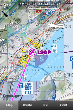
Air Navigation Pro est compatible avec des cartes d’approche géo-référencées qui peuvent être ouvertes sur la carte.
Nous offrons un an d’abonnement qui comprend des:
- Mises à jour régulières en fonction des cycles d’amendement.
- Cartes d’approche géo-référencées pour être utilisées sur la carte.
- Cartes d’approche en format PDF
(avec des infos supplémentaires).
Pour plus d'information, lisez l'article Installation.
Le Carte d'approche comprend des:
- Cartes d’approche géo-référencées pour être utilisées sur la carte.
- Cartes d’approche en format PDF
(avec des infos supplémentaires)
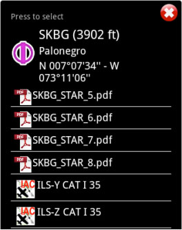
Les deux peuvent être ouverts en sélectionnant un waypoint sur la carte. À titre d’exemple, nous avons sélectionné le waypoint SKBG de la carte défilante. Les fichiers affichés sur la partie supérieure de la liste sont les documents PDF, tandis que les fichiers affichés sur la partie inférieure de la liste sont les carte d’approche géo-référencées. (classées comme VFR ou IFR)
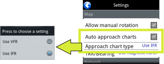
We will set the class of the approach (VFR/IFR) chart we want to use in the Settings panel, where the user can also enable or disable the option «Auto approach chart». When enabled, the geo-referenced approach charts will be opened on the map automatically by Air Nav Pro for the destination waypoint.
Example: if I create a Route: SKBG - SKBO - SAEZ.
If we have downloaded the approach charts for SAEZ, then an approach chart will pop up on the map when SAEZ is our next selected waypoint.
Back to index.


