| Line 3: | Line 3: | ||
<br /> | <br /> | ||
---- | ---- | ||
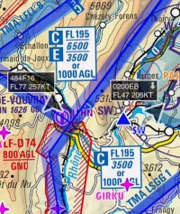
| − | [[File:traffic_arrows.jpg| | + | [[File:traffic_arrows.jpg|caption|right|200px]]When connected to an ADS-B or FLARM transmitter (See [[Sensors#Traffic_Sources|Traffic Sources]]), Air Navigation Pro will show traffic information on the moving Map as moving arrows. |
| − | + | <br /> | |
| − | The arrows will contain following information: | + | The arrows will contain the following information: |
* '''Callsign''' | * '''Callsign''' | ||
* '''Altitude''' | * '''Altitude''' | ||
* '''Speed''' | * '''Speed''' | ||
| − | * '''Vertical Speed''' (as an upward or downward arrow | + | * '''Vertical Speed''' (as an upward or downward arrow. No arrow means the aircraft is leveled). |
<br /> | <br /> | ||
The direction of the arrow is the heading of the aircraft. A trail of previous recorded positions of the aircraft will be displayed as a dot trace. | The direction of the arrow is the heading of the aircraft. A trail of previous recorded positions of the aircraft will be displayed as a dot trace. | ||
[[File:Traffic_favourite.png|left]]You can tap on one of the arrows and set it as a "favourite" to follow it. The colour of the arrow will then change to yellow. | [[File:Traffic_favourite.png|left]]You can tap on one of the arrows and set it as a "favourite" to follow it. The colour of the arrow will then change to yellow. | ||
| + | |||
| + | |||
| + | ---- | ||
| + | <br /> | ||
| + | Back to <u>[[Air Navigation iOS|index]]</u> | ||
| + | <br /> | ||
</translate> | </translate> | ||
Revision as of 15:19, 20 October 2015
When connected to an ADS-B or FLARM transmitter (See Traffic Sources), Air Navigation Pro will show traffic information on the moving Map as moving arrows.
The arrows will contain the following information:
- Callsign
- Altitude
- Speed
- Vertical Speed (as an upward or downward arrow. No arrow means the aircraft is leveled).
The direction of the arrow is the heading of the aircraft. A trail of previous recorded positions of the aircraft will be displayed as a dot trace.
Back to index

