Line 6:
Line 6: === Helligkeit ===
=== Helligkeit ===
Steuert die Helligkeit des Bildschirms.
Steuert die Helligkeit des Bildschirms.
+ === Nachtmodus ===
+ Kehrt die Farben des Moving Maps für komfortable Nachtflüge um.
=== Karten anzeigen ===
=== Karten anzeigen ===
Aktiviert oder deaktiviert die Hintergrundskarten.
Aktiviert oder deaktiviert die Hintergrundskarten.
Latest revision as of 19:38, 3 August 2017
Information about message (contribute ) This message has no documentation.
If you know where or how this message is used, you can help other translators by adding documentation to this message.
Message definition (Map Options )
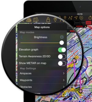
[[Map Options]] displays the map settings module. In the map settings you can configure what will be displayed on the map and how.
[[Map Options]] displays the map settings module. In the map settings you can configure what will be displayed on the map and how.
<br />
 [[File:Map_options_menu_1.png|right|300px]]__TOC__
<br />
=='''Map modes'''==
=== Brightness ===
You can adjust the brightness of the app from here.
=== Night mode ===
Offers to switch the map to a negative mode.
=== Elevation graph ===
Enables or disables the terrain elevation graph for both [[Moving Map]] & [[3D View]].
=== Terrain awareness 2D/3D ===
Enables or disables the terrain awareness for both [[Moving Map]] and [[3D View]].
=== Show METAR on map===
Displays icons over the Airports according to the weather conditions (V for VMC, I for IMC, M for Marginal VMC) on the map. An Internet connection is needed to use this feature.
----
=='''Map settings'''==
=== [[Airspaces]] ===
=== [[Waypoints]] ===
=== [[Obstacles]] ===
=== [[Traffic awareness]] ===
=== [[Widgets]] ===
=== [[Maps]] ===
----
<br />
Back to <u>[[Toolbar|previous page.]]</u>
<br />
[[Category:Map Options]]
Translation Kartenoptionen zeigt die Einstellungen der Karte an. Sie können u.a. wählen welche Objekte auf der Karte eingezeichnet werden sollen. Kartenoptionen zeigt die Einstellungen der Karte an. Sie können u.a. wählen welche Objekte auf der Karte eingezeichnet werden sollen.
Anzeigeoptionen Helligkeit Steuert die Helligkeit des Bildschirms.
Nachtmodus Kehrt die Farben des Moving Maps für komfortable Nachtflüge um.
Karten anzeigen Aktiviert oder deaktiviert die Hintergrundskarten.
Höhengrafik Blendet das Höhenprofil auf dem Moving Map und 3D Ansicht ein oder aus.
Geländewarnung 2D/3D Aktiviert oder deaktiviert die „Terrain awareness“ sowohl für die Moving Map als die 3D Ansicht .
METAR auf der Karte anzeigen Zeigt Symbole auf den Flughäfen laut die aktuelle Wetterbedingungen an. V for VMC, I for IMC, M for Marginal VMC. Eine Internet-Verbindung ist nötig, um diese Funktion zu nutzen.
Karteneinstellugen vorhergehenden Seite.
