(Created page with "Sensoren") |
(Created page with "<br /> ---- 200pxDas Sensoren-Menü von Air Navigation zeigt die unterschiedliche Verbindungen, die in der Navigation als Datenquellen benu...") |
||
| Line 2: | Line 2: | ||
<br /> | <br /> | ||
---- | ---- | ||
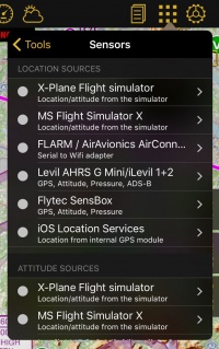
| − | [[File:sensorsc.jpg|caption|right|200px]] | + | [[File:sensorsc.jpg|caption|right|200px]]Das Sensoren-Menü von Air Navigation zeigt die unterschiedliche Verbindungen, die in der Navigation als Datenquellen benutzt werden können. |
<br /> | <br /> | ||
| − | + | Es gibt 4 Arten von Sensoren: | |
| − | * ''' | + | * '''Ortung Sensoren''': Geben Ihre aktuelle Position und Höhe an. (GPS-basiert). |
| − | * ''' | + | * '''Neigung Sensoren''': Geben Fluglage-Information für die 3D Ansicht an. |
| − | * ''' | + | * '''Druck Sensoren''': Geben Druckhöhe-Information an. |
| − | * '''Traffic | + | * '''Traffic Sensoren''': Geben Information über nahgelegenen Flugzeugen an. |
<br /> | <br /> | ||
| − | + | Manche externe Empfänger haben mehrere Sensoren. Als Beispiel gibt den Levil AHRS G Ortung-, Neigung-, Druck- und Traffic-Information an Air Navigation Pro. | |
<br /> | <br /> | ||
__TOC__ | __TOC__ | ||
<br /> | <br /> | ||
----- | ----- | ||
| − | == | + | ==Ortung Sensoren== |
| − | ''' | + | '''Flugsimulatoren''' |
| − | * Air Navigation Pro | + | * Air Navigation Pro verbindet sich mit Flugsimulatoren und nutzt den als Datenquelle für die angezeigte Daten: |
**MS Flight Simulator X / Prepar3D | **MS Flight Simulator X / Prepar3D | ||
** X-Plane | ** X-Plane | ||
<br /> | <br /> | ||
| − | ''' | + | '''Externe Empfänger''' |
| − | * | + | * Externe Empfänger die Standortinformation an Air Navigation Pro übermitteln: |
** Flytec SensBox | ** Flytec SensBox | ||
** Levil AHRS G Mini and iLevil 1 & 2 | ** Levil AHRS G Mini and iLevil 1 & 2 | ||
** FLARM / AirAvionics Air Connect | ** FLARM / AirAvionics Air Connect | ||
<br /> | <br /> | ||
| − | '''iOS | + | '''iOS Ortung Service''' |
| − | * | + | * Verwendet für interne oder externe GPS-Empfänger. Externe GPS-Empfänger wie die von Bad-Elf, Garmin oder Dual benutzen diesen Sensor ebenso. |
<br /> | <br /> | ||
---- | ---- | ||
| − | == | + | ==Neigung Sensoren== |
| − | ''' | + | '''Flugsimulatoren''' |
| − | * Air Navigation Pro | + | * Air Navigation Pro verbindet sich mit Flugsimulatoren und nutzt den als Datenquelle für die angezeigte Daten: |
**MS Flight Simulator X / Prepar3D | **MS Flight Simulator X / Prepar3D | ||
** X-Plane | ** X-Plane | ||
<br /> | <br /> | ||
| − | ''' | + | '''Externe Empfänger''' |
| − | * | + | * Externe Empfänger die Fluglage-Information an Air Navigation Pro übermitteln: |
** Flytec SensBox | ** Flytec SensBox | ||
** Levil AHRS G Mini and iLevil 1 & 2 | ** Levil AHRS G Mini and iLevil 1 & 2 | ||
<br /> | <br /> | ||
| − | ''' | + | '''iOS IMU''' |
| − | * | + | * Verbindung zu den 3-Achsen Gyro- und Beschleunigungssensor des iPads/iPhones. |
<br /> | <br /> | ||
---- | ---- | ||
| − | == | + | ==Druck Sensoren== |
| − | ''' | + | '''Flugsimulatoren''' |
| − | * Air Navigation Pro | + | * Air Navigation Pro verbindet sich mit Flugsimulatoren und nutzt den als Datenquelle für die angezeigte Daten: |
** MS Flight Simulator X / Prepar3D | ** MS Flight Simulator X / Prepar3D | ||
** X-Plane | ** X-Plane | ||
<br /> | <br /> | ||
| − | ''' | + | '''Externe Empfänger''' |
| − | * | + | * Externe Empfänger die Drucknformation an Air Navigation Pro übermitteln: |
** Flytec SensBox | ** Flytec SensBox | ||
** Levil AHRS G Mini and iLevil 1 & 2 | ** Levil AHRS G Mini and iLevil 1 & 2 | ||
** ASI FlyNET2 | ** ASI FlyNET2 | ||
<br /> | <br /> | ||
| − | ''' | + | '''Internes Barometer''' |
| − | * | + | * Beginnend mit iPhone 6 & iPad Air 2, sind die Geräte mit einem internen Barometer ausgestattet. Air Navigation benutzt die Daten des Barometers um die Druckhöhe zu zeigen. |
<br /> | <br /> | ||
---- | ---- | ||
| − | <u>''' | + | <u>'''Hinweis:'''</u> Beim Verwenden des Barometers in einer Druckkabine wird die Kabinenhöhe angezeigt (Nicht die Flughöhe!). Um das zu korrigieren, schalten Sie das interne Barometer aus und benutzen sie die GPS-basierte Höhe. |
---- | ---- | ||
Revision as of 21:11, 19 October 2016
Das Sensoren-Menü von Air Navigation zeigt die unterschiedliche Verbindungen, die in der Navigation als Datenquellen benutzt werden können.
Es gibt 4 Arten von Sensoren:
- Ortung Sensoren: Geben Ihre aktuelle Position und Höhe an. (GPS-basiert).
- Neigung Sensoren: Geben Fluglage-Information für die 3D Ansicht an.
- Druck Sensoren: Geben Druckhöhe-Information an.
- Traffic Sensoren: Geben Information über nahgelegenen Flugzeugen an.
Manche externe Empfänger haben mehrere Sensoren. Als Beispiel gibt den Levil AHRS G Ortung-, Neigung-, Druck- und Traffic-Information an Air Navigation Pro.
Ortung Sensoren
Flugsimulatoren
- Air Navigation Pro verbindet sich mit Flugsimulatoren und nutzt den als Datenquelle für die angezeigte Daten:
- MS Flight Simulator X / Prepar3D
- X-Plane
Externe Empfänger
- Externe Empfänger die Standortinformation an Air Navigation Pro übermitteln:
- Flytec SensBox
- Levil AHRS G Mini and iLevil 1 & 2
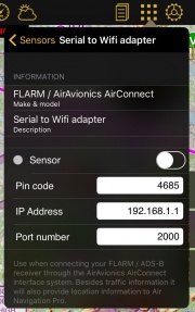
- FLARM / AirAvionics Air Connect
iOS Ortung Service
- Verwendet für interne oder externe GPS-Empfänger. Externe GPS-Empfänger wie die von Bad-Elf, Garmin oder Dual benutzen diesen Sensor ebenso.
Neigung Sensoren
Flugsimulatoren
- Air Navigation Pro verbindet sich mit Flugsimulatoren und nutzt den als Datenquelle für die angezeigte Daten:
- MS Flight Simulator X / Prepar3D
- X-Plane
Externe Empfänger
- Externe Empfänger die Fluglage-Information an Air Navigation Pro übermitteln:
- Flytec SensBox
- Levil AHRS G Mini and iLevil 1 & 2
iOS IMU
- Verbindung zu den 3-Achsen Gyro- und Beschleunigungssensor des iPads/iPhones.
Druck Sensoren
Flugsimulatoren
- Air Navigation Pro verbindet sich mit Flugsimulatoren und nutzt den als Datenquelle für die angezeigte Daten:
- MS Flight Simulator X / Prepar3D
- X-Plane
Externe Empfänger
- Externe Empfänger die Drucknformation an Air Navigation Pro übermitteln:
- Flytec SensBox
- Levil AHRS G Mini and iLevil 1 & 2
- ASI FlyNET2
Internes Barometer
- Beginnend mit iPhone 6 & iPad Air 2, sind die Geräte mit einem internen Barometer ausgestattet. Air Navigation benutzt die Daten des Barometers um die Druckhöhe zu zeigen.
Hinweis: Beim Verwenden des Barometers in einer Druckkabine wird die Kabinenhöhe angezeigt (Nicht die Flughöhe!). Um das zu korrigieren, schalten Sie das interne Barometer aus und benutzen sie die GPS-basierte Höhe.
Traffic Sources
Levil AHRS G Mini and iLevil 1 & 2- Uses the ADS-B information and displays it on the moving map
FLARM / Air Avionics Air Connect
- FLARM receivers are only compatible with Air Navigation Pro when using Air Connect from Air Avionics.
Air Navigation Traffic Service Collaborative traffic sharing
- This service will push your current position together with the traffic received by your ADS-B or FLARM device to our server. You will be provided with information sent by other Air Navigation users.
Note: Other ADS-B receivers like PilotAware have also been proven compatible with Air Navigation. The connection to Air Navigation Pro has to be made via WiFi for these devices to work. We do not deliver a full list of compatible devices. We have done testing with the above mentioned devices, we can not guarantee that other devices will work as well.
Back to previous page.

