(Created page with "<br /> ---- El modo editar, le permitirá crear fácilmente una ruta. Cambiará la forma de interactuar con Air Navigation y la información que se mostrará para planear su r...") |
(Created page with "=== Barra de búsqueda en el panel de rutas === * Alternativamente, se puede entrar uno o varios identificadores de waypoints en el campo de búsqueda del módulo «Rutas» y...") |
||
| Line 14: | Line 14: | ||
<br /> | <br /> | ||
| − | === | + | === Barra de búsqueda en el panel de rutas === |
| − | * | + | * Alternativamente, se puede entrar uno o varios identificadores de waypoints en el campo de búsqueda del módulo «Rutas» y presionar retorno. Identificadores múltiples tendrían que estar separados por un espacio. |
| − | + | ||
<u>'''Note:'''</u> to find a waypoint near an airfield, typically VFR report points, you can use the following syntax: | <u>'''Note:'''</u> to find a waypoint near an airfield, typically VFR report points, you can use the following syntax: | ||
Revision as of 15:59, 7 October 2016
El modo editar, le permitirá crear fácilmente una ruta. Cambiará la forma de interactuar con Air Navigation y la información que se mostrará para planear su ruta mejor.
Contents
Crear una ruta
Directo en el mapa móvil
- Cambie a «Modo Editar», una barra con rayas amarillas y negras debería aparecer en la parte superior del mapa móvil. El icono del candado se abrirá. Apretando en la barra, el modo editar se cerrará.
- Para agregar waypoints, presione sobre waypoints de su elección en el mapa móvil. En la ventana emergente, seleccione la opción «Agregar a la ruta». Una estrella amarilla debería ser vista ahora en el mapa móvil y su waypoint debería incluirse en lista del panel de «Rutas».
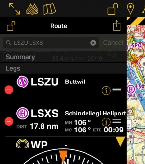
Barra de búsqueda en el panel de rutas
- Alternativamente, se puede entrar uno o varios identificadores de waypoints en el campo de búsqueda del módulo «Rutas» y presionar retorno. Identificadores múltiples tendrían que estar separados por un espacio.
Note: to find a waypoint near an airfield, typically VFR report points, you can use the following syntax: W@LSZG (waypoint id@airfield id) then return. This will force Air Navigation to find the closest waypoint from LSZG with the identifier W.
Using the Search Module
- Use the Search Module to look for any waypoint in the database and add it to the route.
Modifying a route
In Edit mode it is also possible to reorder and remove waypoints from the list in the «Route instrument». Alternatively, you can remove a waypoint by pressing on the map and choose the «remove from route» option.
It is possible to insert a waypoint by pressing on the magenta vector (leg) and dragging it to a waypoint on the map. As a result a new waypoint will be inserted in the «Route». If the location on the map is not over an existing waypoint, a «temporary» waypoint will be created. You can add this waypoint later to the database if you wish to do so. You can also do this by tapping on a waypoint of the route and dragging it to a new location.
You can create a new waypoint by pressing 2 seconds at its location on the map. A popup will ask if you want to add this point at the end of the actual route or insert it to the database and use it later.
Other relevant information
- While in Edit Mode you will be able to create and modify the route. Once you go out from Edit Mode the route will be static and editing will not be possible. You can easily recognize on what mode you are by looking at the padlock icon and the yellow/black bar at the top of the screen.
- While creating a route you will be able to see the terrain between two points in the elevation profile and also changing to the 3D View. You can change the leg displayed by choosing it on the route instrument.
Back to previous page.
