| Line 2: | Line 2: | ||
<br /> | <br /> | ||
---- | ---- | ||
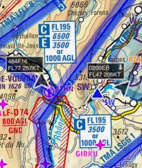
| − | [[File:traffic_arrows.jpg|caption|right|200px]] | + | [[File:traffic_arrows.jpg|caption|right|200px]]When connected to an ADS-B or FLARM transmitter (See [[Sensors#Traffic_Sources|Traffic Sources]]), Air Navigation Pro will show traffic information on the moving Map as moving arrows. The arrow will be coloured dark if the traffic is at a similar altitude as you. Otherwise it will be coloured light grey and no tag will be displayed. Close traffic will be shown in red and you will receive an alert if there is traffic close to you around the same altitude. |
<br /> | <br /> | ||
| − | + | The tag next to the arrow will contain the following information: | |
| − | * | + | *Callsign |
| − | * | + | *Altitude |
| − | * | + | *Speed |
| − | * | + | *Vertical Speed (as an upward or downward arrow. No arrow means the aircraft is levelled). |
<br /> | <br /> | ||
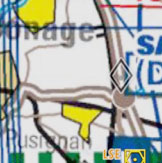
| − | + | The direction of the arrow is the heading of the aircraft. A trail of previous recorded positions of the aircraft will be displayed as a dot trace. | |
__TOC__ | __TOC__ | ||
Revision as of 20:38, 3 November 2015
When connected to an ADS-B or FLARM transmitter (See Traffic Sources), Air Navigation Pro will show traffic information on the moving Map as moving arrows. The arrow will be coloured dark if the traffic is at a similar altitude as you. Otherwise it will be coloured light grey and no tag will be displayed. Close traffic will be shown in red and you will receive an alert if there is traffic close to you around the same altitude.
The tag next to the arrow will contain the following information:
- Callsign
- Altitude
- Speed
- Vertical Speed (as an upward or downward arrow. No arrow means the aircraft is levelled).
The direction of the arrow is the heading of the aircraft. A trail of previous recorded positions of the aircraft will be displayed as a dot trace.
Contents
Bookmark traffics
You can tap on one of the arrows and set it as "favourite" to follow it. The colour of the arrow will then change to yellow. This feature can be helpful to highlight a colleague you are flying with for example or if you plan to fly in close formation. Notice that you won't receive collision warning from aircrafts that are marked as favourites.
TCAS Mode
The Traffic awareness is set by default in the Nearby mode. You can change it to the TCAS mode by going to "Map Options - Traffic Awareness".
The TCAS mode uses the same algorithm as the TCAS present in airplanes. It will not issue a Resolution Advisory though.
Note: Air Navigation Pro will warn you for a collision following the TCAS rules but no resolution will be issued.
Back to index.


