(Marked this version for translation) |
|||
| Line 3: | Line 3: | ||
<br /> | <br /> | ||
---- | ---- | ||
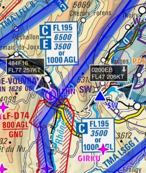
| − | + | [[File:traffic_arrows.jpg|thumb|right]]When connected to an ADS-B or FLARM transmitter (See [[Sensors#Traffic_Sources|Traffic Sources]]), Air Navigation Pro will show traffic information on the moving Map as moving arrows. | |
| − | + | The arrows will contain following information: | |
| − | + | * '''Callsign''' | |
| − | * | + | * '''Altitude''' |
| + | * '''Speed''' | ||
| + | * '''Vertical Speed''' (as an upward or downward arrow, no arrow means the aircraft is leveled) | ||
| + | <br /> | ||
| + | The direction of the arrow is the heading of the aircraft. | ||
| − | + | [[File:Traffic_favourite.png|left]]You can tap on one of the arrows and set it as a "favourite". The colour of the arrow will then change to yellow | |
| − | + | ||
| − | + | ||
| − | + | ||
| − | + | ||
| − | + | ||
</translate> | </translate> | ||
Revision as of 14:23, 20 October 2015
When connected to an ADS-B or FLARM transmitter (See Traffic Sources), Air Navigation Pro will show traffic information on the moving Map as moving arrows.
The arrows will contain following information:
- Callsign
- Altitude
- Speed
- Vertical Speed (as an upward or downward arrow, no arrow means the aircraft is leveled)
The direction of the arrow is the heading of the aircraft.

