(Importing a new version from external source) |
(Importing a new version from external source) |
||
| Line 5: | Line 5: | ||
| − | The altimeter instrument of Air Navigation displays altitudes above Mean sea level ( | + | The altimeter instrument of Air Navigation displays altitudes above Mean sea level (MSL) as reported from the GPS unit. Usually the altitude has an accuracy of 70 ft or less. This is usually even better with external GPS modules. |
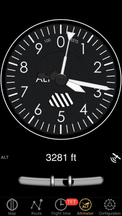
The top part is the analog altimeter indicator. At the bottom part you will find the digital altimeter value as well as the current GPS status symbol. | The top part is the analog altimeter indicator. At the bottom part you will find the digital altimeter value as well as the current GPS status symbol. | ||
Revision as of 16:42, 3 November 2016
The altimeter of Air Navigation is GPS based like all navigation instruments. Nevertheless, it should never be used as a replacement for the barometric altimeter.
The altimeter instrument of Air Navigation displays altitudes above Mean sea level (MSL) as reported from the GPS unit. Usually the altitude has an accuracy of 70 ft or less. This is usually even better with external GPS modules.
The top part is the analog altimeter indicator. At the bottom part you will find the digital altimeter value as well as the current GPS status symbol.
The altimeter unit can be set as feet or meters in the application's settings.
A question mark will be shown instead of a digital altimeter value when:- GPS accuracy is more than 230 ft.
Note: remember that you will ONLY find the spinball at the bottom of the instrument on iPhone/iPod Touch devices.
Back to previous page.
