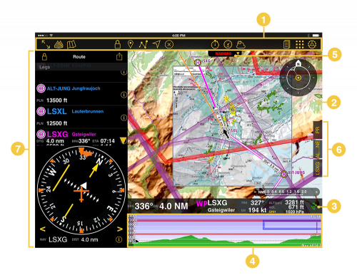
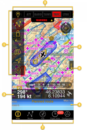
(Created page with ";# Symbolleiste ;# Moving Map ;# Datenleiste ;# Höhenprofil ;# Sensorenstatus ;#...") |
|||
| Line 25: | Line 25: | ||
| − | ;# [[Toolbar]] | + | ;# [[Toolbar/de|Symbolleiste]] |
| − | ;# [[Moving Map]] | + | ;# [[Moving Map/de|Moving Map]] |
| − | ;# [[Data Bar]] | + | ;# [[Data Bar/de|Datenleiste]] |
| − | ;# [[Elevation Graph]] | + | ;# [[Elevation Graph/de|Höhenprofil]] |
| − | ;# [[Sensor Status]] | + | ;# [[Sensor Status/de |Sensorenstatus]] |
| − | ;# [[Docks]] | + | ;# [[Docks/de|Docks]] |
| − | ;# [[Instruments]] | + | ;# [[Instruments/de|Instrumente]] |
Revision as of 14:26, 20 October 2016
Air Navigation ist eine sehr intuitive und benutzerfreundliche Software. Die Benutzeroberfläche wurde entwickelt um alle Flug wichtigen Informationen auf einen Blick an zu zeigen. Generell gilt für die Oberfläche: Gelb: Interaktion ist möglich Grau/Weiß: Nur Information, Interaktion nicht möglich.
iPad
iPhone
Note: Please note that iPhone's docks will only be visible in iPhone 6 and others with bigger screens.
Back to previous page.

