(Importing a new version from external source) |
(Importing a new version from external source) |
||
| Line 9: | Line 9: | ||
[[File:operationalf.jpg]] | [[File:operationalf.jpg]] | ||
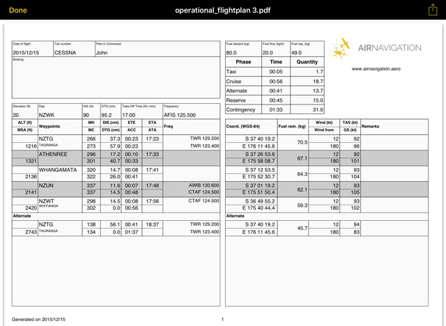
| − | The flight log will display route information in an easy to read table mode together with other relevant information like MSA, FREQs, TAS, GS and Fuel requirements. | + | The flight log will display route information in an easy-to-read table mode together with other relevant information like MSA, FREQs, TAS, GS and Fuel requirements. |
To print, send or share the Operational Flightplan just tap on the icon with the arrow on the upper right corner. | To print, send or share the Operational Flightplan just tap on the icon with the arrow on the upper right corner. | ||
| + | ===Legs=== | ||
| + | Will display information about the legs of the Route. While flying, it will display the actual distance and bearing to next waypoint. | ||
| + | |||
| + | Pressing the "i" at the right of every WP will show information of the WP and the option to select it or center it on the map. | ||
| + | |||
| + | === Edit Mode === | ||
| + | When in Edit Mode the information displayed will be distance, heading, course and ETE between the route's waypoints. | ||
| + | |||
| + | You will also be able to change the order of the waypoints by tapping the three lines at the right of the waypoint and dragging the waypoint up or down. By tapping on the red "-" at the left of the waypoint you will be able to remove it from the route. | ||
Back to <u>[[Air Navigation iOS|index]]</u> | Back to <u>[[Air Navigation iOS|index]]</u> | ||
<br /> | <br /> | ||
Revision as of 16:29, 21 October 2016
Operational Flightplan
The route created can be converted to a flight log that can be printed out or sent by E-Mail.
To use this function just tap on the Summary of the route and select the option "Flightplan" at the top right corner.
The flight log will display route information in an easy-to-read table mode together with other relevant information like MSA, FREQs, TAS, GS and Fuel requirements.
To print, send or share the Operational Flightplan just tap on the icon with the arrow on the upper right corner.
Legs
Will display information about the legs of the Route. While flying, it will display the actual distance and bearing to next waypoint.
Pressing the "i" at the right of every WP will show information of the WP and the option to select it or center it on the map.
Edit Mode
When in Edit Mode the information displayed will be distance, heading, course and ETE between the route's waypoints.
You will also be able to change the order of the waypoints by tapping the three lines at the right of the waypoint and dragging the waypoint up or down. By tapping on the red "-" at the left of the waypoint you will be able to remove it from the route.
Back to index
