| (3 intermediate revisions by the same user not shown) | |||
| Line 1: | Line 1: | ||
| + | <languages /> | ||
| + | <translate> | ||
| + | <!--T:1--> | ||
| + | <br /> | ||
---- | ---- | ||
[[File:geo_mac.jpg|caption|left]] | [[File:geo_mac.jpg|caption|left]] | ||
| − | As a complement, Air | + | <!--T:2--> |
| + | As a complement, Air Navigation Desktop supports georeferenced approach charts. | ||
| − | [[File:danger.jpg|caption]] Geo-referenced approach charts are paid subscriptions and | + | <!--T:3--> |
| + | [[File:danger.jpg|caption]] Geo-referenced approach charts are paid subscriptions and have to be purchased from your Xample Services account. | ||
| − | The approach chart can be opened as a PDF document | + | <!--T:4--> |
| − | route. In both cases, you | + | The approach chart can be opened as a PDF document. Or it can be displayed on the map to better plan the route. In both cases, you have to '''select them in the info window''' of the airport waypoint. |
| + | <!--T:5--> | ||
[[File:geo_mac2.jpg|caption|left]] Here’s an example where an approach chart for the Airport LFOJ is opened and geo-referenced on the moving map. | [[File:geo_mac2.jpg|caption|left]] Here’s an example where an approach chart for the Airport LFOJ is opened and geo-referenced on the moving map. | ||
| Line 28: | Line 35: | ||
| − | <blockquote>''' | + | <!--T:6--> |
| + | <blockquote>'''Right-click on the map and select "Hide approach chart" from the pop-up window to remove the chart from the screen.''' </blockquote><br/> | ||
| + | <!--T:7--> | ||
---- | ---- | ||
<br/> | <br/> | ||
Back to <u>[[Air Navigation Desktop|index]]</u> | Back to <u>[[Air Navigation Desktop|index]]</u> | ||
| + | <br /> | ||
| + | </translate> | ||
Latest revision as of 15:06, 4 November 2015
As a complement, Air Navigation Desktop supports georeferenced approach charts.
caption Geo-referenced approach charts are paid subscriptions and have to be purchased from your Xample Services account.
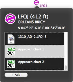
The approach chart can be opened as a PDF document. Or it can be displayed on the map to better plan the route. In both cases, you have to select them in the info window of the airport waypoint.
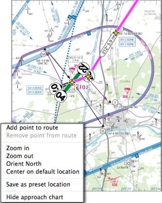
Right-click on the map and select "Hide approach chart" from the pop-up window to remove the chart from the screen.
Back to index

