Latest revision as of 14:34, 4 November 2015
Information about message (contribute ) This message has no documentation.
If you know where or how this message is used, you can help other translators by adding documentation to this message.
Message definition (Create a route )
<br />
<br />
----
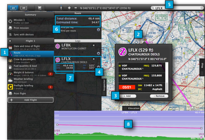
Here are the steps to follow in order to create a route in Air Navigation Desktop:
# Within the Mission TAB, select the Route module
# Choose a waypoint from the map that you wish to add to the route
# Click on '''«Add»''' button from the popup window
# The waypoint will be added to the Route list
# As an alternative, you can add a waypoint to the route through the search field
# Total distance and estimated time shows on the top of the Route module
# Partial distance and estimated times per leg show on each waypoint
# The route will be also represented in the elevation graph
<br/>
[[File:danger.jpg|caption|left]] The elevation graph will show terrain only if the elevation data has been downloaded.
<br/>
[[File:danger.jpg|caption|left]] Estimated times will show as long as the cruise speed is set in the aircraft profile.
<br/>
[[File:mac1mac.jpg]]
Translation <br />
Hier finden Sie die empfohlene Schritte, um eine Route in Air Nav Desktop zu erstellen:
In der “Mission”-Registerkarte, wählen Sie das Routen Modul aus
Suchen Sie auf der Karte den Wegpunkt, den Sie zur Route hinzufügen wollen aus
Klicken Sie auf die «Add» Schaltfläche
Der Wegpunkt wird zur Routen-Liste hinzugefügt
Als Alternative, können Sie den Wegpunkt durch das Suchfeld zur Route hinzufügen
Gesamtstrecke und die voraussichtliche Zeit wird auf der Oberseite des Routen-Moduls angezeigt
Entfernung und geschätzte Zeiten pro Abschnitt werden auf jedem Wegpunkt angezeigt
Die Strecke wird auch im Elevation Graphen dargestellt
Der Elevation Graph wird das Gelände nur anzeigen, wenn die Höhendaten heruntergeladen wurden.
Geschätzte Zeiten werden nur angezeigt, wenn die Flugreise-Informationen im Flugzeugprofil eingegeben wurden.
