(Created page with "Traffic awareness") |
(Created page with "<br /> ---- 200pxCuando se conecta a un transmisor ADS-B o FLARM (ver Fuentes de tráfico), Air Navigatio...") |
||
| Line 2: | Line 2: | ||
<br /> | <br /> | ||
---- | ---- | ||
| − | [[File:traffic_arrows.jpg|caption|right|200px]] | + | [[File:traffic_arrows.jpg|caption|right|200px]]Cuando se conecta a un transmisor ADS-B o FLARM (ver [[Sensors#Traffic_Sources|Fuentes de tráfico]]), Air Navigation Pro exhibirá las informaciones tráfico en el mapa móvil como si fuesen flechas en movimiento. |
<br /> | <br /> | ||
| − | + | Las flechas contendrán la información siguiente: | |
| − | * ''' | + | * '''Indicativo''' |
| − | * ''' | + | * '''Actitud''' |
| − | * ''' | + | * '''Velocidad''' |
| − | * ''' | + | * '''Velocidad vertical''' (como una flecha apuntando hacia arriba o abajo. Ninguna flecha implica que la aeronave está nivelada). |
<br /> | <br /> | ||
| − | + | La dirección de la flecha es el rumbo de la aeronave. of the arrow is the heading of the aircraft. Una rastro de las posiciones previas de la aeronave aparecerá como un trazo punteado. | |
[[File:Traffic_favourite.png|left]]You can tap on one of the arrows and set it as a "favourite" to follow it. The colour of the arrow will then change to yellow. | [[File:Traffic_favourite.png|left]]You can tap on one of the arrows and set it as a "favourite" to follow it. The colour of the arrow will then change to yellow. | ||
Revision as of 18:56, 20 October 2015
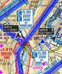
Cuando se conecta a un transmisor ADS-B o FLARM (ver Fuentes de tráfico), Air Navigation Pro exhibirá las informaciones tráfico en el mapa móvil como si fuesen flechas en movimiento.
Las flechas contendrán la información siguiente:
- Indicativo
- Actitud
- Velocidad
- Velocidad vertical (como una flecha apuntando hacia arriba o abajo. Ninguna flecha implica que la aeronave está nivelada).
La dirección de la flecha es el rumbo de la aeronave. of the arrow is the heading of the aircraft. Una rastro de las posiciones previas de la aeronave aparecerá como un trazo punteado.
Back to index

