Line 2:
Line 2: <br/>
<br/>
<u>'''Waypoints'''</u>
<u>'''Waypoints'''</u>
− [[File:waypoints_mac.jpg|caption|left]] In this module, you can '''filter''', '''show''' or '''hide''' difFerent types of waypoints to be displayed in the map, including:
+ [[File:waypoints_mac.jpg|caption|left]] In this module, you can '''filter''', '''show''' or '''hide''' different types of waypoints to be displayed in the map, including:
*Airport
*Airport
*Fix (Visual Reporting Point)
*Fix (Visual Reporting Point)
Latest revision as of 20:22, 19 October 2015
Information about message (contribute ) This message has no documentation.
If you know where or how this message is used, you can help other translators by adding documentation to this message.
Message definition (Map TAB )
[[File:danger.jpg|caption|left]] NOTAMs and Obstacles are paid subscriptions and shall be purchased from your Xample Services account.
[[File:danger.jpg|caption|left]] NOTAMs and Obstacles are paid subscriptions and shall be purchased from your Xample Services account.
<br/>
<u>'''Waypoints'''</u>
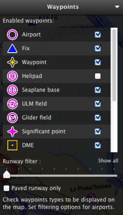
[[File:waypoints_mac.jpg|caption|left]] In this module, you can '''filter''', '''show''' or '''hide''' different types of waypoints to be displayed in the map, including:
*Airport
*Fix (Visual Reporting Point)
*User Waypoint (waypoint created by the user)
*Helipad
*Seaplane base
*ULM field
*Glider field
*Significant point (IFR waypoint)
*DME
*NDB
*VOR
*NDB DME
*VOR DME
*TACAN
*VORTAC
<br/>
For Airfields, it is also possible to '''filter by runway length''' and '''surface type.'''
Translation [[File:danger.jpg|caption|left]] NOTAMs and Obstacles are paid subscriptions and shall be purchased from your Xample Services account. NOTAMs and Obstacles are paid subscriptions and shall be purchased from your Xample Services account.
Waypoints
In this module, you can
filter ,
show or
hide different types of waypoints to be displayed in the map, including:
Airport
Fix (Visual Reporting Point)
User Waypoint (waypoint created by the user)
Helipad
Seaplane base
ULM field
Glider field
Significant point (IFR waypoint)
DME
NDB
VOR
NDB DME
VOR DME
TACAN
VORTAC filter by runway length and surface type.
