| (2 intermediate revisions by the same user not shown) | |||
| Line 1: | Line 1: | ||
| + | <languages /> | ||
| + | <translate> | ||
| + | <!--T:1--> | ||
| + | <br /> | ||
---- | ---- | ||
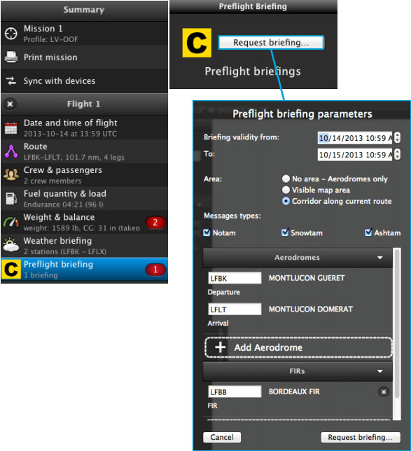
The preflight briefing provides with '''NOTAM information''' to the pilot, who can change the parameters in the module, to show more or limit that information. The parameters are described in the picture below. | The preflight briefing provides with '''NOTAM information''' to the pilot, who can change the parameters in the module, to show more or limit that information. The parameters are described in the picture below. | ||
| − | [[File:danger.jpg|caption|left]] NOTAM is a paid subscription and | + | <!--T:2--> |
| + | [[File:danger.jpg|caption|left]] NOTAM is a paid subscription and has to be purchased from your Xample Services account. | ||
| + | <!--T:3--> | ||
[[File:danger.jpg|caption|left]] Check NOTAM service availability in your country. | [[File:danger.jpg|caption|left]] Check NOTAM service availability in your country. | ||
| + | <!--T:4--> | ||
[[File:weather_mac4.jpg]] | [[File:weather_mac4.jpg]] | ||
| + | <!--T:5--> | ||
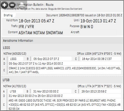
The NOTAM is presented in PDF format and can be immediately '''printed out.''' | The NOTAM is presented in PDF format and can be immediately '''printed out.''' | ||
| + | <!--T:6--> | ||
The '''Availability''' of this service covers most of the world territory on NOTAM serie A, Europe on '''NOTAM series A and C''', and France, Germany and Switzerland on '''smart NOTAM'''. Here’s what each type means: | The '''Availability''' of this service covers most of the world territory on NOTAM serie A, Europe on '''NOTAM series A and C''', and France, Germany and Switzerland on '''smart NOTAM'''. Here’s what each type means: | ||
* NOTAM serie A: | * NOTAM serie A: | ||
| Line 21: | Line 30: | ||
Decoded NOTAM (easy-to-read) | Decoded NOTAM (easy-to-read) | ||
| + | <!--T:7--> | ||
[[File:notam_mac.jpg]] | [[File:notam_mac.jpg]] | ||
| + | <!--T:8--> | ||
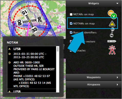
NOTAM can also be activated on the map through the Map TAB widgets. On the image beside, the NOTAM is depicted as '''red dotted circles.''' You can get the NOTAM info by clicking within the circles (see screenshot below). | NOTAM can also be activated on the map through the Map TAB widgets. On the image beside, the NOTAM is depicted as '''red dotted circles.''' You can get the NOTAM info by clicking within the circles (see screenshot below). | ||
| + | <!--T:9--> | ||
[[File:notam_mac2.jpg]] | [[File:notam_mac2.jpg]] | ||
| + | <!--T:10--> | ||
---- | ---- | ||
<br/> | <br/> | ||
Back to <u>[[Air Navigation Desktop|index]]</u> | Back to <u>[[Air Navigation Desktop|index]]</u> | ||
| + | <br /> | ||
| + | </translate> | ||
Latest revision as of 22:03, 15 October 2015
The preflight briefing provides with NOTAM information to the pilot, who can change the parameters in the module, to show more or limit that information. The parameters are described in the picture below.
NOTAM is a paid subscription and has to be purchased from your Xample Services account.
The NOTAM is presented in PDF format and can be immediately printed out.
The Availability of this service covers most of the world territory on NOTAM serie A, Europe on NOTAM series A and C, and France, Germany and Switzerland on smart NOTAM. Here’s what each type means:
- NOTAM serie A:
International Airports + FIR regions
- NOTAM serie C:
National/Regional Airports
- Smart NOTAM:
Decoded NOTAM (easy-to-read)
NOTAM can also be activated on the map through the Map TAB widgets. On the image beside, the NOTAM is depicted as red dotted circles. You can get the NOTAM info by clicking within the circles (see screenshot below).
Back to index


