(Created page with "Montrer/cacher l’arrière-plan de la carte (les cartes installées).") |
(Updating to match new version of source page) |
||
| (6 intermediate revisions by 2 users not shown) | |||
| Line 2: | Line 2: | ||
<br /> | <br /> | ||
---- | ---- | ||
| + | From this menu you can show, hide and reorder your installed maps. You can display several maps from different providers and use them all at the same time. | ||
| + | <br /> | ||
| + | __TOC__ | ||
| + | <br /> | ||
| + | ---- | ||
| + | ==Satellite photos== | ||
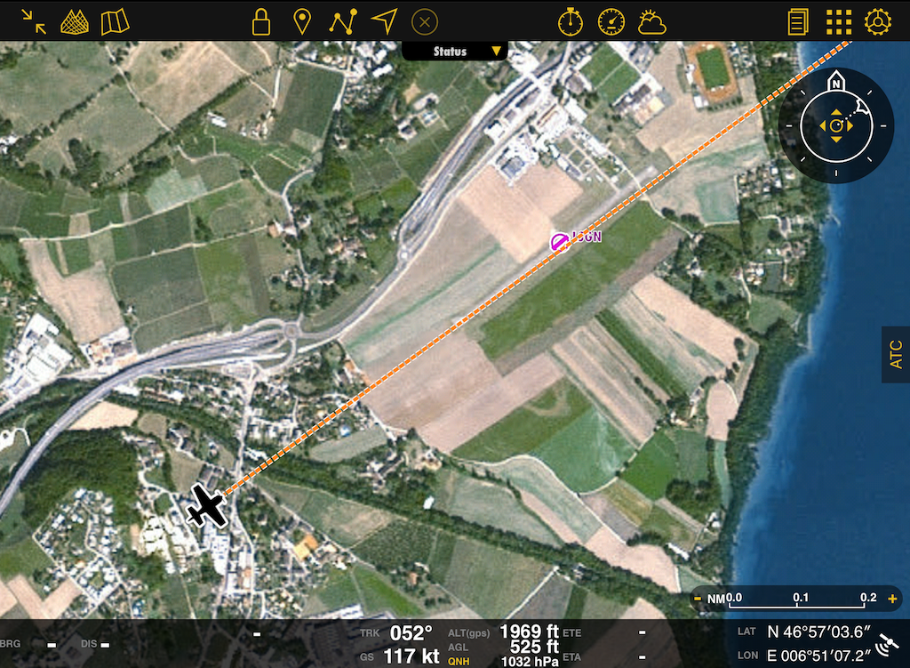
| + | It is possible to show satellite imagery on the [[Moving Map]]. For this function to work the [[3D View]] data package for your area has to be downloaded from the [[Map Store]]. | ||
| + | [[File:Satellite.PNG]] | ||
| + | ---- | ||
| + | ==Drag to reorder== | ||
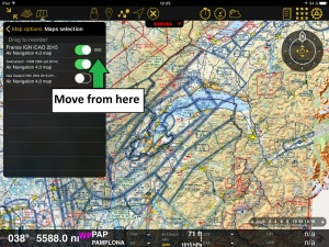
| + | [[File:overlay3.jpg|caption|right|300px]]By pressing and holding the right edge of the chart, you'll be able to reorder the position of the charts. This is useful for when two charts show the same area and you want to display one on top of the other. | ||
| + | <br /> | ||
| + | <br /> | ||
| + | For example: | ||
| + | In the screenshot on the right, we show both the chart “France IGN ICAO 2015” and the chart “Switzerland 2014” one on top of the other. The problem looks like if the French chart is missing a part, but actually, '''''it is not.''''' This is a clear example of <span style="color:#ff0000">OVERLAYING.</span> | ||
| − | + | [[File:overlay2.jpg|400px]] | |
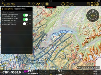
| − | + | You can solve this problem by simply moving the charts up or down in the '''«Maps»''' panel or switching them ON or OFF. | |
| + | On the picture on the right, we show the chart from Switzerland on top of the one from France. | ||
| + | So, if we move it below, the latter will show on top of the former. This is shown on the picture above. | ||
| + | ---- | ||
| + | ==Troubleshooting== | ||
| + | ; My installed maps are not showing | ||
| + | : Check that they're enabled under [[Map Options]] - Maps. If they are and you are still not seeing them, make sure to place them at the top of the list. They might be hidden behind another chart. | ||
| + | ; I cannot erase maps | ||
| + | : You can erase maps from [[Configuration]] - [[Products (Map Store)]] - Installed products | ||
---- | ---- | ||
<br /> | <br /> | ||
| − | Back to <u>[[ | + | Back to <u>[[Map_Options|previous page.]]</u> |
<br /> | <br /> | ||
| + | [[Category:Map Options]] | ||
Latest revision as of 21:47, 30 November 2017
From this menu you can show, hide and reorder your installed maps. You can display several maps from different providers and use them all at the same time.
Satellite photos
It is possible to show satellite imagery on the Moving Map. For this function to work the 3D View data package for your area has to be downloaded from the Map Store.

Drag to reorder
By pressing and holding the right edge of the chart, you'll be able to reorder the position of the charts. This is useful for when two charts show the same area and you want to display one on top of the other.
For example:
In the screenshot on the right, we show both the chart “France IGN ICAO 2015” and the chart “Switzerland 2014” one on top of the other. The problem looks like if the French chart is missing a part, but actually, it is not. This is a clear example of OVERLAYING.
You can solve this problem by simply moving the charts up or down in the «Maps» panel or switching them ON or OFF. On the picture on the right, we show the chart from Switzerland on top of the one from France. So, if we move it below, the latter will show on top of the former. This is shown on the picture above.
Troubleshooting
- My installed maps are not showing
- Check that they're enabled under Map Options - Maps. If they are and you are still not seeing them, make sure to place them at the top of the list. They might be hidden behind another chart.
- I cannot erase maps
- You can erase maps from Configuration - Products (Map Store) - Installed products
Back to previous page.

