(Importing a new version from external source) |
(Importing a new version from external source) |
||
| (9 intermediate revisions by 2 users not shown) | |||
| Line 17: | Line 17: | ||
To access the embedded web server, type this address in the URL bar in a reasonably up to date Internet Browser (Firefox 3, Safari 4, Explorer 8) on your computer and press return. Air Navigation website should appear in your navigator. | To access the embedded web server, type this address in the URL bar in a reasonably up to date Internet Browser (Firefox 3, Safari 4, Explorer 8) on your computer and press return. Air Navigation website should appear in your navigator. | ||
---- | ---- | ||
| − | [[File: | + | [[File:warning_sign.png|caption|left]] If you fail to connect, try several times and on different browsers. |
| + | |||
---- | ---- | ||
| Line 29: | Line 30: | ||
http://apple.com/support/downloads/bonjourforwindows.html | http://apple.com/support/downloads/bonjourforwindows.html | ||
---- | ---- | ||
| − | On the browser, available data is grouped by type: Navigation plans, Waypoints, Airspaces, Recorded flights, Logbook | + | On the browser, available data is grouped by type: Navigation plans, Waypoints, Airspaces, Recorded flights, Logbook. |
Tap on a group bar to disclose its content. Some data types can only be uploaded or deleted (Airspaces or maps), some can only be downloaded and deleted (Recorded flights) and some others can be uploaded, downloaded or deleted (Waypoints, Navigation | Tap on a group bar to disclose its content. Some data types can only be uploaded or deleted (Airspaces or maps), some can only be downloaded and deleted (Recorded flights) and some others can be uploaded, downloaded or deleted (Waypoints, Navigation | ||
| Line 38: | Line 39: | ||
To download a file, press the <span style="color:#006400">green arrow</span> on the right side of the file. The red circle is used to delete a file. | To download a file, press the <span style="color:#006400">green arrow</span> on the right side of the file. The red circle is used to delete a file. | ||
| − | To | + | To import a file in a particular group, press the file icon with the <span style="color:#0000CD">blue arrow</span> on the right side of the group name. A selection popup will appear on top of the page. |
| − | On most | + | On most browsers, after a file is selected, it will start uploading immediately. |
| − | On older | + | On older browsers, you may need to press the «Upload» button to start uploading. |
To upload a '''PDF document''' and associate it to a specific airfield, you must add the ICAO code of the airport where you want the PDF to appear at the beginning of the pdf name ( Example: LSGG _Geneva_approach.pdf ). You can then upload the document in the «Appcharts» section. If Air Navigation cannot find an airfield | To upload a '''PDF document''' and associate it to a specific airfield, you must add the ICAO code of the airport where you want the PDF to appear at the beginning of the pdf name ( Example: LSGG _Geneva_approach.pdf ). You can then upload the document in the «Appcharts» section. If Air Navigation cannot find an airfield | ||
matching the 4 letter prefix of the file, an error message will appear and the PDF will not be installed. | matching the 4 letter prefix of the file, an error message will appear and the PDF will not be installed. | ||
| + | |||
| + | ---- | ||
| + | <u>'''Note:'''</u> make sure to separate the ICAO code of the airfield from the airfield's name using an underscore (_). | ||
| + | ---- | ||
---- | ---- | ||
| Line 52: | Line 57: | ||
You can also upload waypoints and airspaces using this feature. However, it is necessary to respect the file format. Please, click on the kind of data below for further information about its structure: | You can also upload waypoints and airspaces using this feature. However, it is necessary to respect the file format. Please, click on the kind of data below for further information about its structure: | ||
| − | *[[Airspace file]] | + | *<u>[[Airspace file]]</u> |
| − | *[[Waypoints file]] | + | *<u>[[Waypoints file]]</u> |
<br /> | <br /> | ||
Latest revision as of 19:54, 31 August 2017
How to use the Webserver
The iPhone/iPod must be connected to a wifi network. Additionally, the wifi network must be the same network as the one on your desktop computer.
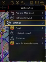
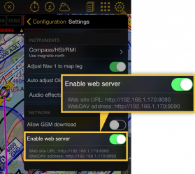
The web server must be turned on in the «Settings» module. If the web server is on, its network address will appear just below the web server switch. Example: http://192.168.46:8080


To access the embedded web server, type this address in the URL bar in a reasonably up to date Internet Browser (Firefox 3, Safari 4, Explorer 8) on your computer and press return. Air Navigation website should appear in your navigator.
If you fail to connect, try several times and on different browsers.
Note: if you have the Bonjour application installed on your computer, the web server will appear automatically as part of the detected websites, in this case you don’t have to type the
IP address manually. Bonjour is installed automatically on Mac computers, on Windows it comes together with iTunes.
Should you wish to install the plugin manually, please download the latest installer at this address:
http://apple.com/support/downloads/bonjourforwindows.html
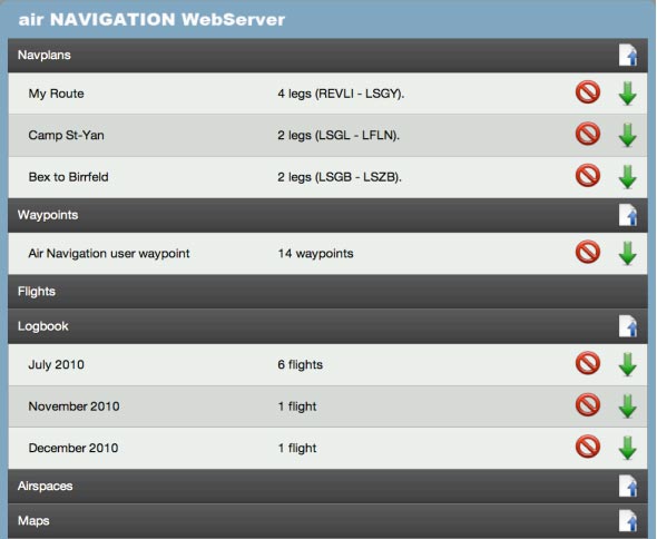
On the browser, available data is grouped by type: Navigation plans, Waypoints, Airspaces, Recorded flights, Logbook.
Tap on a group bar to disclose its content. Some data types can only be uploaded or deleted (Airspaces or maps), some can only be downloaded and deleted (Recorded flights) and some others can be uploaded, downloaded or deleted (Waypoints, Navigation plans, logbook).
To download a file, press the green arrow on the right side of the file. The red circle is used to delete a file.
To import a file in a particular group, press the file icon with the blue arrow on the right side of the group name. A selection popup will appear on top of the page. On most browsers, after a file is selected, it will start uploading immediately. On older browsers, you may need to press the «Upload» button to start uploading.
To upload a PDF document and associate it to a specific airfield, you must add the ICAO code of the airport where you want the PDF to appear at the beginning of the pdf name ( Example: LSGG _Geneva_approach.pdf ). You can then upload the document in the «Appcharts» section. If Air Navigation cannot find an airfield matching the 4 letter prefix of the file, an error message will appear and the PDF will not be installed.
Note: make sure to separate the ICAO code of the airfield from the airfield's name using an underscore (_).
Format & Compatibility
You can also upload waypoints and airspaces using this feature. However, it is necessary to respect the file format. Please, click on the kind of data below for further information about its structure:
Back to previous page.
