(Created page with "Le HSI est le plus pratique des instruments de navigation, mais il requiert également un peu d’entraînement afin d’être utilisé efficacement.") |
|||
| (39 intermediate revisions by 2 users not shown) | |||
| Line 1: | Line 1: | ||
<languages /> | <languages /> | ||
| + | <br /> | ||
---- | ---- | ||
| − | [[File: | + | [[File:hsi_instr.jpg|250px|caption|left]] |
| − | + | Air Navigation peut simuler un HSI (Horizontal Situation Indicator - Indicateur de Situation Horizontale). | |
| − | + | L’aiguille jaune est l’indicateur de sélection de route (OBS), la partie mobile du milieu est l’indicateur d’écart de route (CDI) qui affiche la déviation (+/- 12 degrés) à partir du radial sélectionné ou la route vers ou du waypoint sélectionné. | |
| − | + | Contrairement à un vrai HSI où le curseur orange sert à définir une route pour le pilote automatique, le curseur affiche le relèvement du waypoint sélectionné. Le HSI n’affiche pas non plus le cap mais la trajectoire de l’avion. | |
| − | + | ||
| − | + | Le cadran de la boussole tournera automatiquement pour suivre la trajectoire actuelle. | |
| − | + | La sélection d’un radial ou d’une route se fait par un toucher-glisser haut ou bas à gauche ou à droite de la bordure du cadran. | |
| − | [[File: | + | [[File:warning_sign.png]] Un drapeau d’avertissement “NAV” vous signalera que vous NE devez PAS faire confiance aux indications du HSO dans les cas suivants: |
| − | * | + | * Aucun waypoint n’est sélectionné pour l’instrument; |
| − | * | + | * Le waypoint est à plus de 250 NM; |
| − | * | + | * La précision du GPS est mauvaise; |
| − | * | + | * La vitesse sol est inférieure à 5 nœuds. |
| − | <br/> | + | <br /> |
---- | ---- | ||
| − | < | + | <u>'''Notez bien:'''</u> Même si la précision du GPS est inférieure à 2,5 nautiques, l’information de déviation sera néanmoins correcte. Dans ce cas, le cadran sera orienté au nord. |
---- | ---- | ||
| − | + | Le nom du waypoint sélectionné, sa distance ainsi que les données et le statut du GPS s’affichent sous le cadran principal (grand cercle). Vous pouvez utiliser n’importe quel type de waypoint (aéroport, VOR, NDB, etc) avec le HSI émulé contrairement à un vrai HSI qui nécessite des signaux radio émis d’un VOR, d’un VOR/DME ou d’un VORTAC. | |
| − | + | Vous pouvez choisir un nouveau waypoint dans la base de données grâce au bouton “i” dans la partie inférieure de l’instrument (voir la copie d’écran). | |
| − | + | Reportez-vous au <u>[[Search Module/fr|Module de Recherche]]</u> pour plus d’informations à propos d’une recherche et sélection d’un waypoint (Version iOS). | |
| − | [[File: | + | [[File:hsi_info.jpg]] |
| − | |||
---- | ---- | ||
| − | + | <u>'''Notez bien:'''</u> La bille au bas de l’instrument se trouve UNIQUEMENT sur l’iPhone ou l’iPod Touch. | |
| + | ---- | ||
| + | ---- | ||
| + | Retourner à la <u>[[Air Navigation Android/fr|page précédente.]]</u> (Android) | ||
| − | + | Retourner à la <u>[[Instruments/fr|page précédente.]]</u> (iOS) | |
| + | <br /> | ||
| + | [[Category:Instruments/fr]] | ||
Latest revision as of 19:20, 23 August 2017
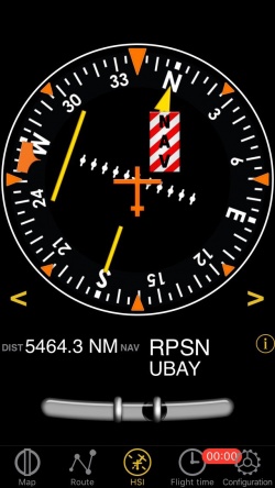
Air Navigation peut simuler un HSI (Horizontal Situation Indicator - Indicateur de Situation Horizontale).
L’aiguille jaune est l’indicateur de sélection de route (OBS), la partie mobile du milieu est l’indicateur d’écart de route (CDI) qui affiche la déviation (+/- 12 degrés) à partir du radial sélectionné ou la route vers ou du waypoint sélectionné.
Contrairement à un vrai HSI où le curseur orange sert à définir une route pour le pilote automatique, le curseur affiche le relèvement du waypoint sélectionné. Le HSI n’affiche pas non plus le cap mais la trajectoire de l’avion.
Le cadran de la boussole tournera automatiquement pour suivre la trajectoire actuelle. La sélection d’un radial ou d’une route se fait par un toucher-glisser haut ou bas à gauche ou à droite de la bordure du cadran.
![]() Un drapeau d’avertissement “NAV” vous signalera que vous NE devez PAS faire confiance aux indications du HSO dans les cas suivants:
Un drapeau d’avertissement “NAV” vous signalera que vous NE devez PAS faire confiance aux indications du HSO dans les cas suivants:
- Aucun waypoint n’est sélectionné pour l’instrument;
- Le waypoint est à plus de 250 NM;
- La précision du GPS est mauvaise;
- La vitesse sol est inférieure à 5 nœuds.
Notez bien: Même si la précision du GPS est inférieure à 2,5 nautiques, l’information de déviation sera néanmoins correcte. Dans ce cas, le cadran sera orienté au nord.
Le nom du waypoint sélectionné, sa distance ainsi que les données et le statut du GPS s’affichent sous le cadran principal (grand cercle). Vous pouvez utiliser n’importe quel type de waypoint (aéroport, VOR, NDB, etc) avec le HSI émulé contrairement à un vrai HSI qui nécessite des signaux radio émis d’un VOR, d’un VOR/DME ou d’un VORTAC.
Vous pouvez choisir un nouveau waypoint dans la base de données grâce au bouton “i” dans la partie inférieure de l’instrument (voir la copie d’écran). Reportez-vous au Module de Recherche pour plus d’informations à propos d’une recherche et sélection d’un waypoint (Version iOS).
Notez bien: La bille au bas de l’instrument se trouve UNIQUEMENT sur l’iPhone ou l’iPod Touch.
Retourner à la page précédente. (Android)
Retourner à la page précédente. (iOS)

