| (18 intermediate revisions by 2 users not shown) | |||
| Line 1: | Line 1: | ||
| − | ---- | + | <languages /> |
| + | <translate> | ||
| + | <!--T:1--> | ||
<br /> | <br /> | ||
| − | + | ---- | |
| − | + | ||
[[Map Options]] displays the map settings module. In the map settings you can configure what will be displayed on the map and how. | [[Map Options]] displays the map settings module. In the map settings you can configure what will be displayed on the map and how. | ||
| − | + | <br /> | |
| − | + | [[File:Map_options_menu_1.png|right|300px]]__TOC__ | |
| − | + | <br /> | |
| − | + | =='''Map modes'''== <!--T:2--> | |
| − | + | ||
| − | + | ||
| − | =='''Map modes'''== | + | |
=== Brightness === | === Brightness === | ||
| − | You can adjust the brightness of the app from here | + | You can adjust the brightness of the app from here. |
| − | === | + | === Night mode === |
| − | + | Offers to switch the map to a negative mode. | |
=== Elevation graph === | === Elevation graph === | ||
Enables or disables the terrain elevation graph for both [[Moving Map]] & [[3D View]]. | Enables or disables the terrain elevation graph for both [[Moving Map]] & [[3D View]]. | ||
| Line 21: | Line 19: | ||
Enables or disables the terrain awareness for both [[Moving Map]] and [[3D View]]. | Enables or disables the terrain awareness for both [[Moving Map]] and [[3D View]]. | ||
=== Show METAR on map=== | === Show METAR on map=== | ||
| − | Displays icons over the Airports according to the weather conditions (V for VMC, I for IMC, M for Marginal VMC) on the map. Internet connection is needed to use this feature | + | Displays icons over the Airports according to the weather conditions (V for VMC, I for IMC, M for Marginal VMC) on the map. An Internet connection is needed to use this feature. |
---- | ---- | ||
| − | |||
=='''Map settings'''== | =='''Map settings'''== | ||
=== [[Airspaces]] === | === [[Airspaces]] === | ||
| Line 31: | Line 28: | ||
=== [[Widgets]] === | === [[Widgets]] === | ||
=== [[Maps]] === | === [[Maps]] === | ||
| − | |||
| − | |||
---- | ---- | ||
| − | Back to <u>[[Toolbar | + | <br /> |
| + | Back to <u>[[Toolbar|previous page.]]</u> | ||
| + | <br /> | ||
| + | [[Category:Map Options]] | ||
| + | </translate> | ||
Latest revision as of 15:37, 1 August 2017
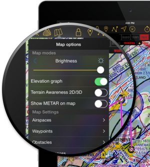
Map Options displays the map settings module. In the map settings you can configure what will be displayed on the map and how.
Contents
Map modes
Brightness
You can adjust the brightness of the app from here.
Night mode
Offers to switch the map to a negative mode.
Elevation graph
Enables or disables the terrain elevation graph for both Moving Map & 3D View.
Terrain awareness 2D/3D
Enables or disables the terrain awareness for both Moving Map and 3D View.
Show METAR on map
Displays icons over the Airports according to the weather conditions (V for VMC, I for IMC, M for Marginal VMC) on the map. An Internet connection is needed to use this feature.
Map settings
Airspaces
Waypoints
Obstacles
Traffic awareness
Widgets
Maps
Back to previous page.
