(Created page with "<br /> ---- 250pxEl instrumento RMI en Air Air Navigation utiliza información proveniente del GPS y no recibe ninguna onda de radio. <br...") |
|||
| (12 intermediate revisions by 2 users not shown) | |||
| Line 2: | Line 2: | ||
<br /> | <br /> | ||
---- | ---- | ||
| − | [[File: | + | [[File:rmi_instr.jpg|caption|left|250px]]El instrumento RMI en Air Navigation utiliza información proveniente del GPS y no recibe ninguna onda de radio. |
<br /> | <br /> | ||
La parte superior es el indicador ADF. La aguja amarilla apunta hacia el waypoint seleccionado que corresponde al eje longitudinal de la aeronave. | La parte superior es el indicador ADF. La aguja amarilla apunta hacia el waypoint seleccionado que corresponde al eje longitudinal de la aeronave. | ||
| − | + | La rosa de los vientos mostrará el rumbo actual. | |
| − | + | Por debajo del indicador principal, el nombre del waypoint activo será exhibido, como también la distancia hasta el waypoint. Es posible seleccionar cualquier tipo de waypoint (Airports, VOR, NDB, etc) con el que trabajará el ADF, a diferencia de un ADF real que requiere waypoints que sean transmisores NDB o AM | |
| − | + | ||
| − | + | Consulte el artículo <u>[[Search Module/es|Módulo de búsqueda]]</u> para más información sobre cómo seleccionar un waypoint de la base de datos. | |
| − | [[File: | + | [[File:Warning_sign.png|caption|left]]Una bandera de advertencia “NAV” le permitirá saber que '''NO''' debe confiar en el indicador ADF indicator en los casos siguientes: |
| − | * | + | * Ningún waypoint ha sido seleccionado para el instrumento; |
| − | * | + | * La distancia al waypoint seleccionado es mayor a 250 millas náuticas; |
| − | * | + | * La precisión del GPS es menor a las 2.5 millas náuticas. |
---- | ---- | ||
| − | <u>''' | + | <u>'''Nota:'''</u> recuerde que en los dispositivos iPhone y iPod Touche SÓLO encontrará el slipball en la parte inferior del instrumento. |
---- | ---- | ||
---- | ---- | ||
<br /> | <br /> | ||
| − | + | Volver a la <u>[[Instruments/es|página anterior.]]</u> | |
| − | [[Category: | + | [[Category:Instrumentos]] |
Latest revision as of 19:46, 25 July 2017
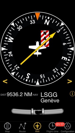
El instrumento RMI en Air Navigation utiliza información proveniente del GPS y no recibe ninguna onda de radio.
La parte superior es el indicador ADF. La aguja amarilla apunta hacia el waypoint seleccionado que corresponde al eje longitudinal de la aeronave.
La rosa de los vientos mostrará el rumbo actual.
Por debajo del indicador principal, el nombre del waypoint activo será exhibido, como también la distancia hasta el waypoint. Es posible seleccionar cualquier tipo de waypoint (Airports, VOR, NDB, etc) con el que trabajará el ADF, a diferencia de un ADF real que requiere waypoints que sean transmisores NDB o AM
Consulte el artículo Módulo de búsqueda para más información sobre cómo seleccionar un waypoint de la base de datos.
Una bandera de advertencia “NAV” le permitirá saber que NO debe confiar en el indicador ADF indicator en los casos siguientes:- Ningún waypoint ha sido seleccionado para el instrumento;
- La distancia al waypoint seleccionado es mayor a 250 millas náuticas;
- La precisión del GPS es menor a las 2.5 millas náuticas.
Nota: recuerde que en los dispositivos iPhone y iPod Touche SÓLO encontrará el slipball en la parte inferior del instrumento.
Volver a la página anterior.
