Latest revision as of 03:05, 15 October 2015
Information about message (contribute ) This message has no documentation.
If you know where or how this message is used, you can help other translators by adding documentation to this message.
Message definition (Map TAB )
----
----
[[File:danger.jpg|caption|left]] Packages such as 3D data, Preflight briefing, Approach Charts and other subscriptions will not show in this module, but under '''«My products»''' section of the Map Store module.
----
<u>'''Elevation'''</u>
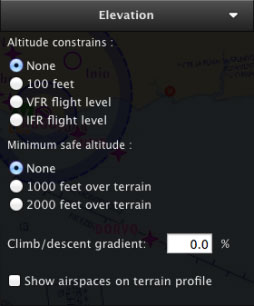
[[File:eleva_mac.jpg|caption|right]]The settings for the <u>[[Elevation TAB | Elevation TAB]]</u> can be found here. Altitude constrains, minimum safe altitude and climb/descent gradient are the options available.
You can also '''show/hide''' airspaces in the Elevation Graph from this module.
Translation ---- Packages such as 3D data, Preflight briefing, Approach Charts and other subscriptions will not show in this module, but under
«My products» section of the Map Store module.
Elevation
The settings for the
Elevation TAB can be found here. Altitude constrains, minimum safe altitude and climb/descent gradient are the options available.
You can also show/hide airspaces in the Elevation Graph from this module.
