(Marked this version for translation) |
|||
| (3 intermediate revisions by the same user not shown) | |||
| Line 9: | Line 9: | ||
* offers to switch the map to a negative mode. | * offers to switch the map to a negative mode. | ||
<br /> | <br /> | ||
| − | ====Map in negative mode==== | + | ====Map in negative mode==== <!--T:1--> |
---- | ---- | ||
[[File:night-mode1.jpg|caption|right|200px]] | [[File:night-mode1.jpg|caption|right|200px]] | ||
| + | <!--T:2--> | ||
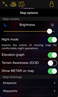
You will find an option to switch to negative color in the <u>[[Map Options]]</u> menu. Below the switch, a warning explains that the original colours of the charts will be transformed.<br /> | You will find an option to switch to negative color in the <u>[[Map Options]]</u> menu. Below the switch, a warning explains that the original colours of the charts will be transformed.<br /> | ||
| + | <!--T:3--> | ||
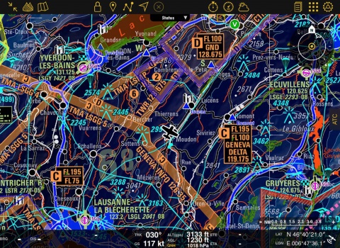
The negative colours are applied only on the charts, so that the metar symbols, obstacles, airspaces and other important information stand out on the moving map. | The negative colours are applied only on the charts, so that the metar symbols, obstacles, airspaces and other important information stand out on the moving map. | ||
| + | <!--T:6--> | ||
| + | [[File:nightmode_landscape.jpg|center|480px]] | ||
| + | |||
| + | <!--T:4--> | ||
<br /> | <br /> | ||
---- | ---- | ||
| − | <u>'''Note:'''</u> | + | <u>'''Note:'''</u> The approach charts are also changeable to negative colors. |
| + | <!--T:5--> | ||
---- | ---- | ||
<br /> | <br /> | ||
Latest revision as of 19:00, 9 June 2017
To accommodate for low light conditions, Air Navigation Pro:
- has black menus.
- offers to reduce the brightness even further than what iOS offers; a grey filter is applied on top of the screen when you decrease the brightness.
- offers to switch the map to a negative mode.
Map in negative mode
You will find an option to switch to negative color in the Map Options menu. Below the switch, a warning explains that the original colours of the charts will be transformed.
The negative colours are applied only on the charts, so that the metar symbols, obstacles, airspaces and other important information stand out on the moving map.
Note: The approach charts are also changeable to negative colors.
Back to previous page.

