(Created page with "; Ancho del corredor : Configurar el ancho del corredor para calcular el MSA (Altitud mínima de seguridad). El corredor se verá como un área roja en el Elevation Graph/e...") |
|||
| (One intermediate revision by the same user not shown) | |||
| Line 1: | Line 1: | ||
; Ancho del corredor | ; Ancho del corredor | ||
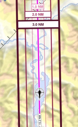
| − | : Configurar el ancho del corredor para calcular el MSA (Altitud mínima de seguridad). El corredor se verá como un área roja en | + | : Configurar el ancho del corredor para calcular el MSA (Altitud mínima de seguridad). El corredor se verá como un área roja en la <u>[[Elevation Graph/es|vista de perfil]]</u>. |
[[File:Corridor_width.jpg|250px|center]] | [[File:Corridor_width.jpg|250px|center]] | ||
Latest revision as of 19:57, 8 June 2017
- Ancho del corredor
- Configurar el ancho del corredor para calcular el MSA (Altitud mínima de seguridad). El corredor se verá como un área roja en la vista de perfil.
