(Marked this version for translation) |
|||
| (5 intermediate revisions by 2 users not shown) | |||
| Line 3: | Line 3: | ||
<!--T:1--> | <!--T:1--> | ||
| + | <br /> | ||
---- | ---- | ||
| − | + | [[File:Dock_5.png|caption|right|250px]] | |
| − | [[File: | + | |
| Line 14: | Line 14: | ||
They will appear on the right side of the moving map after a route is created or loaded. | They will appear on the right side of the moving map after a route is created or loaded. | ||
| + | <!--T:13--> | ||
The Position Report is always shown. | The Position Report is always shown. | ||
| Line 23: | Line 24: | ||
<!--T:4--> | <!--T:4--> | ||
| − | There are four | + | There are four kinds of Docks:<br /> |
*PR<br /> | *PR<br /> | ||
*DEP<br /> | *DEP<br /> | ||
| Line 31: | Line 32: | ||
Tapping on one of the docks, will open up a tab with information related to the waypoint or your position. To close this tab just tap anywhere on the map. | Tapping on one of the docks, will open up a tab with information related to the waypoint or your position. To close this tab just tap anywhere on the map. | ||
| − | ==PR Position Report== | + | <!--T:14--> |
| − | The | + | ---- |
| + | <u>'''Note'''</u>: Please note that iPhone's docks will only be visible in iPhone 6 and others with bigger screens. | ||
| + | ---- | ||
| + | |||
| + | ==PR Position Report== <!--T:15--> | ||
| + | The purpose of this dock is to help you when contacting ATC on the initial call. It will display your current position and intentions in a manner that will quickly let you transmit it over the radio. | ||
| + | |||
| + | <!--T:16--> | ||
[[File:PR.jpg]] | [[File:PR.jpg]] | ||
<br /> | <br /> | ||
| − | ==Airports Docks== | + | ==Airports Docks== <!--T:17--> |
The DEP, ARR and ALTN tabs have four pages:<br /> | The DEP, ARR and ALTN tabs have four pages:<br /> | ||
| Line 47: | Line 55: | ||
<br /> | <br /> | ||
<br /> | <br /> | ||
| + | |||
===== Environment ===== <!--T:6--> | ===== Environment ===== <!--T:6--> | ||
| Line 57: | Line 66: | ||
* Obstacles (*)<br /> | * Obstacles (*)<br /> | ||
<br /> | <br /> | ||
| + | |||
| Line 65: | Line 75: | ||
<br /> | <br /> | ||
<br /> | <br /> | ||
| + | |||
| + | |||
| Line 97: | Line 109: | ||
Back to <u>[[Air_Navigation_overview|previous page.]]</u> | Back to <u>[[Air_Navigation_overview|previous page.]]</u> | ||
<br /> | <br /> | ||
| + | [[Category:Overview]] | ||
</translate> | </translate> | ||
Latest revision as of 16:47, 4 April 2017
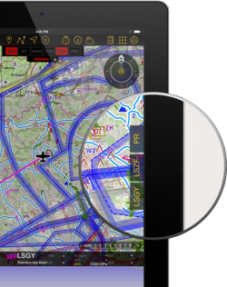
The docks offer you a quick access to relevant information about Departure, Arrival, Alternate airport and your current position.
They will appear on the right side of the moving map after a route is created or loaded.
The Position Report is always shown.
Note: You can set an alternate airport by tapping on the route summary and entering the ID of the airfield in the alternate field.
There are four kinds of Docks:
- PR
- DEP
- ARR
- ALTN
Tapping on one of the docks, will open up a tab with information related to the waypoint or your position. To close this tab just tap anywhere on the map.
Note: Please note that iPhone's docks will only be visible in iPhone 6 and others with bigger screens.
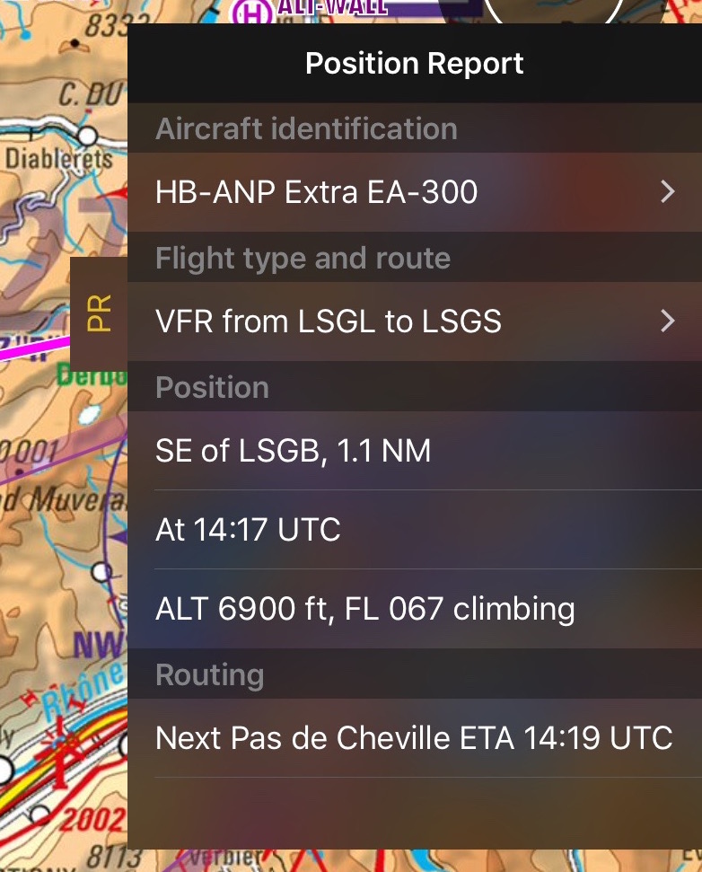
PR Position Report
The purpose of this dock is to help you when contacting ATC on the initial call. It will display your current position and intentions in a manner that will quickly let you transmit it over the radio.
Airports Docks
The DEP, ARR and ALTN tabs have four pages:
Contents
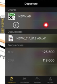
Departure/Approach
On this page you will have access to the charts and documents (*). You will also see the frequencies of the airfield. When tapping on the chart, it will be displayed on the moving map. By tapping on the red cross the chart will be closed. Tapping on the circled arrow will change to the next chart.
You can also see personal .pdf documents that were attached to the airfield.
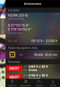
Environment
Will show information about the location of the airfield and surroundings:- Height
- Coordinates
- Sunrise/Sunset time
- Radio Navigation Aids: distance and radial
- Runways
- Obstacles (*)
Weather
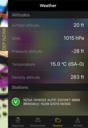
Gathers weather information from the weather stations next to the airfield. The app will calculate altitudes taking in account the current weather. It will also show the METAR. By tapping on a station you will be able to see the report including the TAF.
NOTAM
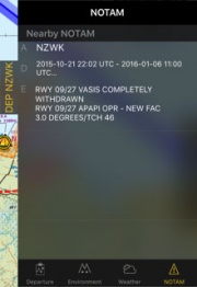
Nearby NOTAMS will be shown. For this page to work you will need to request a briefing first. (*)
Note: If information is missing (weather, NOTAM, etc.), change to the EDIT MODE and go back to flight mode. This will refresh the data of the docks.
Docks can be disabled under "Settings" - "Show route info drawers".
(*) Subscriptions to the mentioned services will be required in order for these functions to work (Preflight Briefing, Approach Charts, Obstacles Database).
Back to previous page.
