(Updating to match new version of source page) |
|||
| (One intermediate revision by the same user not shown) | |||
| Line 1: | Line 1: | ||
<languages /> | <languages /> | ||
| + | <br /> | ||
---- | ---- | ||
| − | [[File: | + | [[File:hsi_instr.jpg|250px|caption|left]] |
| − | + | Air Navigation can simulate an HSI (Horizontal situation indicator). | |
| − | + | The yellow needle is the course select pointer (OBS), the moving part in the middle is the course deviation indicator (CDI) which displays the deviation (+/- 12 degrees) from the selected radial or course to or from the selected waypoint. | |
| − | + | Unlike a real HSI where the orange heading bug is used to set a course for the autopilot, the heading bug displays the bearing to the selected waypoint. Also the HSI does not display heading but the track of the aircraft. | |
| − | + | The compass card will rotate automatically to match the current flying track. | |
| + | Radial or course selection is done by touch and swipe gesture up or down on the left or right of the compass ring. | ||
| − | [[File: | + | [[File:warning_sign.png]] A “NAV” warning flag will let you know that you should '''NOT''' trust the HSI indicator in the following cases: |
| − | * | + | * No waypoint is selected for the instrument; |
| − | * | + | * The waypoint distance is over 250 nautical miles; |
| − | * | + | * The GPS accuracy is bad; |
| − | * | + | * Ground speed is less than 5 Kts. |
| − | <br /> | + | <br/> |
---- | ---- | ||
| − | <u>''' | + | <u>'''Note:'''</u> Please note that you may still get correct deviation information when GPS accuracy is less than 2.5 nautical miles. In this case the compass card will be oriented to the north. |
---- | ---- | ||
| − | + | Below the main indicator, the selected waypoint is displayed as well as the distance from the waypoint (great circle distance) and GPS accuracy. You can use any kind of waypoint (Airports, VOR, NDB, etc) to be used with the HSI instrument. (A real HSI indicator requires radio signals from VOR, VOR/DME or VORTAC transmitters). | |
| − | + | You can select a new waypoint from the database with the blue disclosure button at the bottom part of the instrument (see screenshot). | |
| − | + | Please read <u>[[Search Module]]</u> to get information about waypoint search and selection. (iOS version) | |
| − | [[File: | + | [[File:hsi_info.jpg]] |
| − | |||
---- | ---- | ||
| − | + | <u>'''Note:'''</u> remember that you will ONLY find the slipball at the bottom of the instrument on iPhone/iPod Touch devices. | |
| + | ---- | ||
| + | ---- | ||
| + | Back to <u>[[Air Navigation Android|index]]</u> (Android) | ||
| − | + | Back to <u>[[Instruments|previous page.]]</u> (iOS) | |
<br /> | <br /> | ||
| + | [[Category:Instruments]] | ||
Latest revision as of 17:39, 3 November 2016
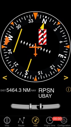
Air Navigation can simulate an HSI (Horizontal situation indicator).
The yellow needle is the course select pointer (OBS), the moving part in the middle is the course deviation indicator (CDI) which displays the deviation (+/- 12 degrees) from the selected radial or course to or from the selected waypoint.
Unlike a real HSI where the orange heading bug is used to set a course for the autopilot, the heading bug displays the bearing to the selected waypoint. Also the HSI does not display heading but the track of the aircraft.
The compass card will rotate automatically to match the current flying track. Radial or course selection is done by touch and swipe gesture up or down on the left or right of the compass ring.
![]() A “NAV” warning flag will let you know that you should NOT trust the HSI indicator in the following cases:
A “NAV” warning flag will let you know that you should NOT trust the HSI indicator in the following cases:
- No waypoint is selected for the instrument;
- The waypoint distance is over 250 nautical miles;
- The GPS accuracy is bad;
- Ground speed is less than 5 Kts.
Note: Please note that you may still get correct deviation information when GPS accuracy is less than 2.5 nautical miles. In this case the compass card will be oriented to the north.
Below the main indicator, the selected waypoint is displayed as well as the distance from the waypoint (great circle distance) and GPS accuracy. You can use any kind of waypoint (Airports, VOR, NDB, etc) to be used with the HSI instrument. (A real HSI indicator requires radio signals from VOR, VOR/DME or VORTAC transmitters).
You can select a new waypoint from the database with the blue disclosure button at the bottom part of the instrument (see screenshot). Please read Search Module to get information about waypoint search and selection. (iOS version)
Note: remember that you will ONLY find the slipball at the bottom of the instrument on iPhone/iPod Touch devices.
Back to index (Android)
Back to previous page. (iOS)

