| Line 4: | Line 4: | ||
<br /> | <br /> | ||
---- | ---- | ||
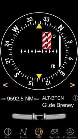
| − | [[File: | + | [[File:vor_instr.jpg|caption|left|250px]]The VOR instrument uses GPS data to display the bearing to a waypoint. |
<br /> | <br /> | ||
The top part is an emulated VOR indicator. The white needle (CDI, Course deviation indicator) will display the current deviation up to +/- 12 degrees relative to the selected radial to or from the course to the selected waypoint. | The top part is an emulated VOR indicator. The white needle (CDI, Course deviation indicator) will display the current deviation up to +/- 12 degrees relative to the selected radial to or from the course to the selected waypoint. | ||
| Line 16: | Line 16: | ||
<!--T:2--> | <!--T:2--> | ||
| − | [[File: | + | [[File:warning_sign.png|caption|left]]A “NAV” warning flag will let you know that you should '''NOT''' trust the VOR indicator in the following cases: |
* No waypoint is selected for the instrument; | * No waypoint is selected for the instrument; | ||
* The waypoint distance is over 250 nautical miles; | * The waypoint distance is over 250 nautical miles; | ||
Revision as of 16:38, 3 November 2016
The VOR instrument uses GPS data to display the bearing to a waypoint.
The top part is an emulated VOR indicator. The white needle (CDI, Course deviation indicator) will display the current deviation up to +/- 12 degrees relative to the selected radial to or from the course to the selected waypoint.
Course and radial selection is done by touching and swiping gesture up or down at the left or right of the compass ring.
Below the main indicator the name of the currently selected waypoint is displayed as well as distance from the waypoint (great circle) and GPS accuracy. You can use any kind of waypoint (Airports, VOR, NDB, etc) with the VOR instrument (whereas a real life VOR indicator requires radio signals from VOR, VOR/DME or VORTAC transmitters). You can select a new waypoint from the database with the blue disclosure button at the bottom part of the instrument. Please read «Selecting waypoints from the database» for more information about it.
A “NAV” warning flag will let you know that you should NOT trust the VOR indicator in the following cases:- No waypoint is selected for the instrument;
- The waypoint distance is over 250 nautical miles;
- The GPS accuracy is less than 2.5 nautical miles.
Note 1: you don't need ground speed to get accurate information on this instrument.
Note 2: remember that you will ONLY find the spinball at the bottom of the instrument on iPhone/iPod Touch devices.
Back to previous page.
