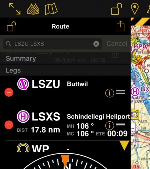
(Created page with "=== Durch Eingabe ins Suchfeld im Routen-Instrument === * Als Alternative können Sie einen oder mehrere Wegpunkte-IDs in das Suchfeld im Routen-Instrument eingeben und '''Suc...") |
(Created page with "<u>'''Hinweis:'''</u> Um einen Wegpunkt in der Nähe eines Flugplatzes zu finden, vor allem VFR-Meldepunkte, können Sie folgende Syntax verwenden: W@LSZG (Wegpunkt ID@Flugpla...") |
||
| Line 17: | Line 17: | ||
* Als Alternative können Sie einen oder mehrere Wegpunkte-IDs in das Suchfeld im Routen-Instrument eingeben und '''Suchen''' tippen. Mehrere IDs müssen durch einen Leerzeichen voneinander getrennt werden. | * Als Alternative können Sie einen oder mehrere Wegpunkte-IDs in das Suchfeld im Routen-Instrument eingeben und '''Suchen''' tippen. Mehrere IDs müssen durch einen Leerzeichen voneinander getrennt werden. | ||
| − | <u>''' | + | <u>'''Hinweis:'''</u> Um einen Wegpunkt in der Nähe eines Flugplatzes zu finden, vor allem VFR-Meldepunkte, können Sie folgende Syntax verwenden: W@LSZG (Wegpunkt ID@Flugplatz ID). Air Navigation wird dann den nächsten Wegpunt zu LSZG mit der ID "W" finden. |
| − | W@LSZG ( | + | |
=== Using the [[Search Module]]=== | === Using the [[Search Module]]=== | ||
Revision as of 19:38, 20 October 2016
Der Editiermodus ermöglicht Ihnen Routen leicht zu erstellen. In den Editiermodus werden in Air Navigation Pro andere Informationen angezeigt um Ihnen die Routenplanung zu erleichtern.
Contents
Route erstellen
Direkt auf dem Moving Map
- Wechseln Sie zum «Editiermodus», eine gelb-schwarze gestreifte Leiste sollte im oberen Teil der Moving Map erscheinen. Das Vorhängeschloss-Icon wird jetzt als offen angezeigt. Sie können den Editiermodus auch verlassen indem Sie auf der Leiste tippen.
- Um Wegpunkte hinzuzufügen, klicken Sie auf einen Wegpunkt Ihrer Wahl auf der Moving Map. Im Wegpunkt-Pop-Up drücken Sie auf «+ Zur Route hinzufügen». Ein gelber Kreis sollte nun auf dem Moving Map erscheinen und der Wegpunkt wird in der Routen-Instrument aufgeführt.
Durch Eingabe ins Suchfeld im Routen-Instrument
- Als Alternative können Sie einen oder mehrere Wegpunkte-IDs in das Suchfeld im Routen-Instrument eingeben und Suchen tippen. Mehrere IDs müssen durch einen Leerzeichen voneinander getrennt werden.
Hinweis: Um einen Wegpunkt in der Nähe eines Flugplatzes zu finden, vor allem VFR-Meldepunkte, können Sie folgende Syntax verwenden: W@LSZG (Wegpunkt ID@Flugplatz ID). Air Navigation wird dann den nächsten Wegpunt zu LSZG mit der ID "W" finden.
Using the Search Module
- Use the Search Module to look for any waypoint in the database and add it to the route.
Modifying a route
In Edit mode it is also possible to reorder and remove waypoints from the list in the «Route instrument». Alternatively, you can remove a waypoint by pressing on the map and choose the «remove from route» option.
It is possible to insert a waypoint by pressing on the magenta vector (leg) and dragging it to a waypoint on the map. As a result a new waypoint will be inserted in the «Route». If the location on the map is not over an existing waypoint, a «temporary» waypoint will be created. You can add this waypoint later to the database if you wish to do so. You can also do this by tapping on a waypoint of the route and dragging it to a new location.
You can create a new waypoint by pressing 2 seconds at its location on the map. A popup will ask if you want to add this point at the end of the actual route or insert it to the database and use it later.
Other relevant information
- While in Edit Mode you will be able to create and modify the route. Once you go out from Edit Mode the route will be static and editing will not be possible. You can easily recognize on what mode you are by looking at the padlock icon and the yellow/black bar at the top of the screen.
- While creating a route you will be able to see the terrain between two points in the elevation profile and also changing to the 3D View. You can change the leg displayed by choosing it on the route instrument.
Back to previous page.
